|
|
|||||||||||||||||
| Point ID: 6540 | Downloads | Plots | Site Data | Other Close Sites | Code: 9030 |
|
|
|||||||||||||||||
| Download | |
|---|---|
| Site Descriptor Information | Site Time Series Data |
| Link to all available data | |
|
|
| View: | Statistics | Time Series |
| Units: | mm |
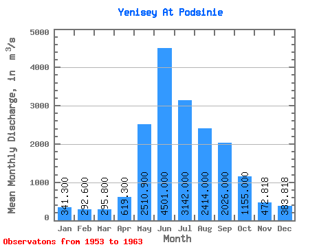
| Statistic | Jan | Feb | Mar | Apr | May | Jun | Jul | Aug | Sep | Oct | Nov | Dec | Annual |
|---|---|---|---|---|---|---|---|---|---|---|---|---|---|
| Mean | 341.30 | 292.60 | 295.80 | 619.30 | 2510.90 | 4501.00 | 3142.00 | 2414.00 | 2026.00 | 1155.00 | 472.82 | 383.82 | 1514.37 |
| Standard Deviation | 42.96 | 39.43 | 40.98 | 285.67 | 861.47 | 634.57 | 767.88 | 460.92 | 248.60 | 76.34 | 82.18 | 49.63 | 172.88 |
| Min | 273.00 | 244.00 | 232.00 | 428.00 | 809.00 | 3640.00 | 1930.00 | 1920.00 | 1630.00 | 1090.00 | 335.00 | 303.00 | 1276.50 |
| Max | 410.00 | 362.00 | 380.00 | 1410.00 | 3570.00 | 5190.00 | 4170.00 | 3170.00 | 2350.00 | 1300.00 | 613.00 | 454.00 | 1819.83 |
| Coefficient of Variation | 0.13 | 0.14 | 0.14 | 0.46 | 0.34 | 0.14 | 0.24 | 0.19 | 0.12 | 0.07 | 0.17 | 0.13 | 0.11 |
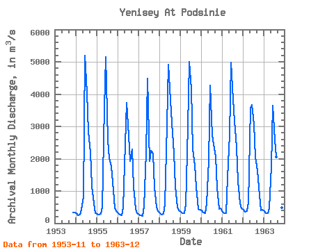
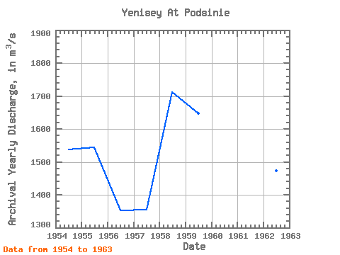
| Year | Jan | Feb | Mar | Apr | May | Jun | Jul | Aug | Sep | Oct | Nov | Dec | Annual | 1953 | 335.00 | 343.00 | 1954 | 317.00 | 245.00 | 277.00 | 428.00 | 809.00 | 5190.00 | 4050.00 | 2830.00 | 2210.00 | 1160.00 | 605.00 | 319.00 | 1536.67 | 1955 | 300.00 | 271.00 | 284.00 | 503.00 | 3570.00 | 5140.00 | 2560.00 | 2020.00 | 1750.00 | 1290.00 | 465.00 | 386.00 | 1544.92 | 1956 | 321.00 | 261.00 | 247.00 | 481.00 | 2460.00 | 3730.00 | 2690.00 | 1920.00 | 2280.00 | 1120.00 | 431.00 | 303.00 | 1353.67 | 1957 | 273.00 | 244.00 | 232.00 | 521.00 | 2180.00 | 4490.00 | 1930.00 | 2240.00 | 2160.00 | 1100.00 | 511.00 | 386.00 | 1355.58 | 1958 | 317.00 | 274.00 | 291.00 | 582.00 | 3070.00 | 4920.00 | 3810.00 | 3100.00 | 2160.00 | 1140.00 | 488.00 | 388.00 | 1711.67 | 1959 | 348.00 | 307.00 | 309.00 | 580.00 | 3000.00 | 5000.00 | 4170.00 | 2290.00 | 1800.00 | 1120.00 | 440.00 | 410.00 | 1647.83 | 1960 | 388.00 | 331.00 | 310.00 | 610.00 | 1940.00 | 4270.00 | 2740.00 | 2450.00 | 2070.00 | 1090.00 | 434.00 | 454.00 | 1423.92 | 1961 | 362.00 | 314.00 | 317.00 | 1410.00 | 2750.00 | 4970.00 | 3830.00 | 3170.00 | 2350.00 | 1300.00 | 613.00 | 452.00 | 1819.83 | 1962 | 410.00 | 362.00 | 380.00 | 624.00 | 3550.00 | 3660.00 | 3070.00 | 2060.00 | 1630.00 | 1110.00 | 400.00 | 421.00 | 1473.08 | 1963 | 377.00 | 317.00 | 311.00 | 454.00 | 1780.00 | 3640.00 | 2570.00 | 2060.00 | 1850.00 | 1120.00 | 479.00 | 360.00 | 1276.50 |
|---|
| Other Close Sites | ||||||
|---|---|---|---|---|---|---|
| PointID | Latitude | Longitude | Drainage Area | Source | Name | |
| 6570 | "Abakan At Raikov" | 53.58 | 86867 | SHI | 38.00 | |
 Return to R-Arctic Net Home Page