|
|
|||||||||||||||||
| Point ID: 6454 | Downloads | Plots | Site Data | Other Close Sites | Code: 8015 |
|
|
|||||||||||||||||
| Download | |
|---|---|
| Site Descriptor Information | Site Time Series Data |
| Link to all available data | |
|
|
| View: | Statistics | Time Series |
| Units: | mm |
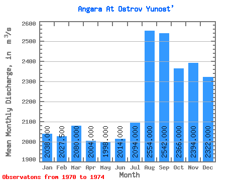
| Statistic | Jan | Feb | Mar | Apr | May | Jun | Jul | Aug | Sep | Oct | Nov | Dec | Annual |
|---|---|---|---|---|---|---|---|---|---|---|---|---|---|
| Mean | 2038.00 | 2027.50 | 2080.00 | 2004.00 | 1998.00 | 2014.00 | 2094.00 | 2554.00 | 2542.00 | 2366.00 | 2394.00 | 2322.00 | 2137.29 |
| Standard Deviation | 394.30 | 188.57 | 161.45 | 440.83 | 310.19 | 301.88 | 536.73 | 954.22 | 985.96 | 629.67 | 585.17 | 528.65 | 345.49 |
| Min | 1590.00 | 1760.00 | 1870.00 | 1560.00 | 1590.00 | 1590.00 | 1620.00 | 1540.00 | 1480.00 | 1570.00 | 1570.00 | 1480.00 | 1770.83 |
| Max | 2640.00 | 2190.00 | 2230.00 | 2730.00 | 2360.00 | 2370.00 | 2920.00 | 3750.00 | 3860.00 | 3140.00 | 2960.00 | 2870.00 | 2527.50 |
| Coefficient of Variation | 0.19 | 0.09 | 0.08 | 0.22 | 0.15 | 0.15 | 0.26 | 0.37 | 0.39 | 0.27 | 0.24 | 0.23 | 0.16 |
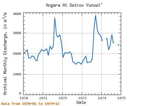
| Year | Jan | Feb | Mar | Apr | May | Jun | Jul | Aug | Sep | Oct | Nov | Dec | Annual | 1970 | 2030.00 | 2120.00 | 2180.00 | 1790.00 | 1780.00 | 1890.00 | 1850.00 | 1710.00 | 1640.00 | 1960.00 | 2090.00 | 2200.00 | 1936.67 | 1971 | 2120.00 | 2190.00 | 2230.00 | 1920.00 | 2360.00 | 2220.00 | 2340.00 | 3750.00 | 2890.00 | 2800.00 | 2920.00 | 2590.00 | 2527.50 | 1972 | 1810.00 | 2040.00 | 2040.00 | 2020.00 | 2080.00 | 2000.00 | 1620.00 | 1540.00 | 1480.00 | 1570.00 | 1570.00 | 1480.00 | 1770.83 | 1973 | 1590.00 | 1760.00 | 1870.00 | 1560.00 | 1590.00 | 1590.00 | 1740.00 | 3240.00 | 3860.00 | 3140.00 | 2960.00 | 2870.00 | 2314.17 | 1974 | 2640.00 | 2730.00 | 2180.00 | 2370.00 | 2920.00 | 2530.00 | 2840.00 | 2360.00 | 2430.00 | 2470.00 |
|---|
| Other Close Sites | ||||||
|---|---|---|---|---|---|---|
| PointID | Latitude | Longitude | Drainage Area | Source | Name | |
| 6453 | "Angara At Irkutskaya GES" | 52.23 | 1018710 | SHI | ||
| 6463 | "Irkut At Irkutsk" | 52.28 | 1016017 | SHI | 2.00 | |
 Return to R-Arctic Net Home Page