|
|
|||||||||||||||||
| Point ID: 2765 | Downloads | Plots | Site Data | Other Close Sites | Code: 10BE006 |
|
|
|||||||||||||||||
| Download | |
|---|---|
| Site Descriptor Information | Site Time Series Data |
| Link to all available data | |
|
|
| View: | Statistics | Time Series |
| Units: | mm |
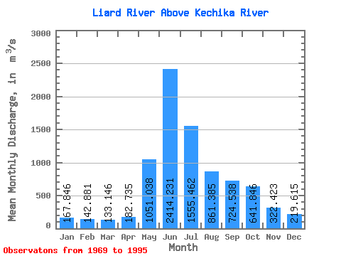
| Statistic | Jan | Feb | Mar | Apr | May | Jun | Jul | Aug | Sep | Oct | Nov | Dec | Annual |
|---|---|---|---|---|---|---|---|---|---|---|---|---|---|
| Mean | 167.85 | 142.88 | 133.15 | 182.74 | 1051.04 | 2414.23 | 1555.46 | 861.38 | 724.54 | 641.85 | 322.42 | 219.62 | 706.15 |
| Standard Deviation | 34.29 | 27.40 | 26.07 | 86.32 | 283.98 | 530.47 | 451.27 | 186.04 | 152.17 | 176.11 | 76.08 | 47.03 | 91.47 |
| Min | 115.00 | 98.90 | 85.70 | 93.10 | 579.00 | 1370.00 | 857.00 | 541.00 | 403.00 | 422.00 | 217.00 | 148.00 | 502.23 |
| Max | 264.00 | 204.00 | 197.00 | 514.00 | 1620.00 | 3620.00 | 2410.00 | 1320.00 | 1190.00 | 1020.00 | 555.00 | 367.00 | 881.50 |
| Coefficient of Variation | 0.20 | 0.19 | 0.20 | 0.47 | 0.27 | 0.22 | 0.29 | 0.22 | 0.21 | 0.27 | 0.24 | 0.21 | 0.13 |
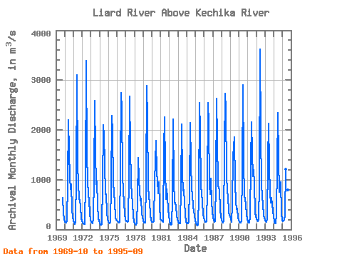
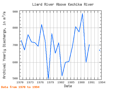
| Year | Jan | Feb | Mar | Apr | May | Jun | Jul | Aug | Sep | Oct | Nov | Dec | Annual | 1969 | 638.00 | 323.00 | 213.00 | 1970 | 154.00 | 144.00 | 141.00 | 159.00 | 953.00 | 2200.00 | 1560.00 | 1040.00 | 810.00 | 912.00 | 401.00 | 245.00 | 726.58 | 1971 | 170.00 | 143.00 | 110.00 | 152.00 | 1040.00 | 3110.00 | 1280.00 | 613.00 | 601.00 | 459.00 | 217.00 | 168.00 | 671.92 | 1972 | 134.00 | 121.00 | 108.00 | 103.00 | 981.00 | 3390.00 | 1490.00 | 1000.00 | 688.00 | 602.00 | 311.00 | 193.00 | 760.08 | 1973 | 153.00 | 136.00 | 117.00 | 203.00 | 1080.00 | 2590.00 | 1550.00 | 917.00 | 970.00 | 492.00 | 219.00 | 176.00 | 716.92 | 1974 | 129.00 | 100.00 | 96.50 | 104.00 | 886.00 | 2100.00 | 1870.00 | 1320.00 | 715.00 | 704.00 | 343.00 | 209.00 | 714.71 | 1975 | 153.00 | 134.00 | 117.00 | 157.00 | 862.00 | 2290.00 | 1940.00 | 945.00 | 732.00 | 559.00 | 237.00 | 191.00 | 693.08 | 1976 | 161.00 | 150.00 | 135.00 | 157.00 | 1190.00 | 2740.00 | 2400.00 | 1080.00 | 772.00 | 538.00 | 315.00 | 196.00 | 819.50 | 1977 | 172.00 | 167.00 | 151.00 | 171.00 | 1100.00 | 2680.00 | 1650.00 | 941.00 | 689.00 | 541.00 | 256.00 | 171.00 | 724.08 | 1978 | 122.00 | 109.00 | 99.70 | 118.00 | 579.00 | 1440.00 | 1020.00 | 753.00 | 587.00 | 619.00 | 327.00 | 253.00 | 502.23 | 1979 | 179.00 | 142.00 | 152.00 | 140.00 | 936.00 | 2890.00 | 2200.00 | 881.00 | 622.00 | 565.00 | 287.00 | 192.00 | 765.50 | 1980 | 157.00 | 157.00 | 147.00 | 166.00 | 963.00 | 1780.00 | 1130.00 | 982.00 | 727.00 | 948.00 | 460.00 | 215.00 | 652.67 | 1981 | 197.00 | 176.00 | 160.00 | 155.00 | 1620.00 | 2260.00 | 1250.00 | 603.00 | 806.00 | 647.00 | 406.00 | 273.00 | 712.75 | 1982 | 168.00 | 101.00 | 93.90 | 104.00 | 592.00 | 2210.00 | 973.00 | 541.00 | 542.00 | 449.00 | 276.00 | 207.00 | 521.41 | 1983 | 168.00 | 124.00 | 122.00 | 122.00 | 854.00 | 2120.00 | 1100.00 | 781.00 | 802.00 | 549.00 | 298.00 | 148.00 | 599.00 | 1984 | 115.00 | 120.00 | 124.00 | 164.00 | 827.00 | 2140.00 | 1340.00 | 799.00 | 716.00 | 463.00 | 273.00 | 174.00 | 604.58 | 1985 | 121.00 | 98.90 | 85.70 | 93.10 | 665.00 | 2540.00 | 2000.00 | 865.00 | 718.00 | 547.00 | 309.00 | 232.00 | 689.56 | 1986 | 192.00 | 147.00 | 146.00 | 171.00 | 803.00 | 2540.00 | 2130.00 | 896.00 | 707.00 | 1020.00 | 555.00 | 367.00 | 806.17 | 1987 | 242.00 | 177.00 | 157.00 | 168.00 | 955.00 | 2630.00 | 1820.00 | 898.00 | 822.00 | 804.00 | 380.00 | 264.00 | 776.42 | 1988 | 194.00 | 153.00 | 134.00 | 170.00 | 1620.00 | 2730.00 | 2410.00 | 1090.00 | 755.00 | 681.00 | 356.00 | 285.00 | 881.50 | 1989 | 264.00 | 204.00 | 151.00 | 514.00 | 1470.00 | 1860.00 | 912.00 | 567.00 | 403.00 | 422.00 | 239.00 | 187.00 | 599.42 | 1990 | 153.00 | 133.00 | 142.00 | 186.00 | 1190.00 | 2910.00 | 1390.00 | 648.00 | 624.00 | 500.00 | 297.00 | 229.00 | 700.17 | 1991 | 153.00 | 143.00 | 138.00 | 253.00 | 1340.00 | 2160.00 | 1520.00 | 1070.00 | 1190.00 | 919.00 | 332.00 | 261.00 | 789.92 | 1992 | 204.00 | 174.00 | 167.00 | 206.00 | 911.00 | 3620.00 | 1920.00 | 906.00 | 646.00 | 524.00 | 269.00 | 235.00 | 815.17 | 1993 | 176.00 | 172.00 | 155.00 | 211.00 | 1390.00 | 2130.00 | 1300.00 | 708.00 | 537.00 | 634.00 | 375.00 | 245.00 | 669.42 | 1994 | 163.00 | 115.00 | 115.00 | 304.00 | 1310.00 | 2340.00 | 1430.00 | 755.00 | 905.00 | 952.00 | 322.00 | 181.00 | 741.00 | 1995 | 170.00 | 174.00 | 197.00 | 300.00 | 1210.00 | 1370.00 | 857.00 | 797.00 | 752.00 |
|---|
| Other Close Sites | ||||||
|---|---|---|---|---|---|---|
| PointID | Latitude | Longitude | Drainage Area | Source | Name | |
| 2758 | "KECHIKA RIVER AT THE MOUTH" | 59.61 | 2024381 | Hydat | ||
 Return to R-Arctic Net Home Page