|
|
|||||||||||||||||
| Point ID: 9622 | Downloads | Plots | Site Data | Code: 05125000 |
|
|
|||||||||||||||||
| Download | |
|---|---|
| Site Descriptor Information | Site Time Series Data |
| Link to all available data | |
|

|
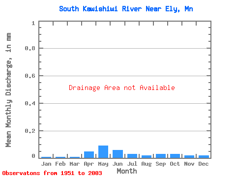
| View: | Statistics | Time Series |
| Units: | m3/s |
| Statistic | Jan | Feb | Mar | Apr | May | Jun | Jul | Aug | Sep | Oct | Nov | Dec | Annual |
|---|---|---|---|---|---|---|---|---|---|---|---|---|---|
| Mean | |||||||||||||
| Standard Deviation | |||||||||||||
| Min | |||||||||||||
| Max | |||||||||||||
| Coefficient of Variation | 0.43 | 0.34 | 0.24 | 0.79 | 0.68 | 0.48 | 0.50 | 0.89 | 0.84 | 1.21 | 0.75 | 0.51 | 0.24 |
| Year | Jan | Feb | Mar | Apr | May | Jun | Jul | Aug | Sep | Oct | Nov | Dec | Annual | 1951 | 1952 | 1953 | 1954 | 1955 | 1956 | 1957 | 1958 | 1959 | 1960 | 1961 | 1976 | 1977 | 1978 | 2003 |
|---|
 Return to R-Arctic Net Home Page