|
|
|||||||||||||||||
| Point ID: 9592 | Downloads | Plots | Site Data | Code: 05123750 |
|
|
|||||||||||||||||
| Download | |
|---|---|
| Site Descriptor Information | Site Time Series Data |
| Link to all available data | |
|
|
| View: | Statistics | Time Series |
| Units: | m3/s |
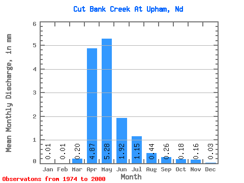
| Statistic | Jan | Feb | Mar | Apr | May | Jun | Jul | Aug | Sep | Oct | Nov | Dec | Annual |
|---|---|---|---|---|---|---|---|---|---|---|---|---|---|
| Mean | 0.00 | 0.00 | 0.08 | 1.83 | 1.99 | 0.72 | 0.43 | 0.16 | 0.10 | 0.07 | 0.06 | 0.01 | 7.72 |
| Standard Deviation | 0.01 | 0.01 | 0.13 | 3.67 | 3.21 | 1.48 | 0.93 | 0.31 | 0.19 | 0.12 | 0.13 | 0.02 | 8.18 |
| Min | 0.00 | 0.00 | 0.00 | 0.00 | 0.00 | 0.00 | 0.00 | 0.00 | 0.00 | 0.00 | 0.00 | 0.00 | 0.04 |
| Max | 0.02 | 0.03 | 0.42 | 11.75 | 9.20 | 4.59 | 3.18 | 1.13 | 0.66 | 0.31 | 0.32 | 0.06 | 16.58 |
| Coefficient of Variation | 2.38 | 3.00 | 1.76 | 2.00 | 1.62 | 2.04 | 2.14 | 1.91 | 1.92 | 1.86 | 2.10 | 1.78 | 1.06 |
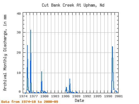
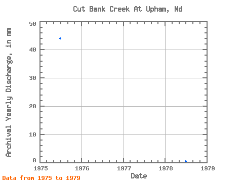
| Year | Jan | Feb | Mar | Apr | May | Jun | Jul | Aug | Sep | Oct | Nov | Dec | Annual | 1974 | 0.00 | 0.00 | 0.00 | 1975 | 0.00 | 0.00 | 0.00 | 0.58 | 9.20 | 3.73 | 1.83 | 0.41 | 0.28 | 0.31 | 0.32 | 0.06 | 16.58 | 1976 | 0.02 | 0.03 | 0.26 | 11.75 | 3.19 | 0.60 | 0.08 | 0.00 | 0.00 | 0.00 | 0.00 | 0.00 | 16.06 | 1977 | 0.00 | 0.00 | 0.00 | 0.01 | 0.02 | 0.01 | 0.00 | 0.00 | 0.00 | 0.00 | 0.00 | 0.00 | 0.04 | 1978 | 0.00 | 0.00 | 0.00 | 0.07 | 0.09 | 0.04 | 0.00 | 0.00 | 0.00 | 0.00 | 0.00 | 0.00 | 0.20 | 1979 | 0.00 | 0.00 | 0.00 | 0.09 | 4.08 | 0.42 | 0.41 | 0.35 | 0.28 | 0.09 | 0.05 | 0.02 | 5.71 | 1980 | 0.00 | 0.00 | 0.00 | 0.26 | 0.20 | 0.02 | 0.00 | 0.00 | 0.00 | 1986 | 0.42 | 1.07 | 1.03 | 0.20 | 0.01 | 0.00 | 0.00 | 1987 | 0.16 | 2.62 | 0.87 | 0.32 | 0.12 | 0.25 | 0.11 | 1988 | 0.00 | 0.00 | 0.08 | 0.09 | 0.01 | 0.00 | 0.00 | 0.00 | 1989 | 0.00 | 0.11 | 0.04 | 0.00 | 0.00 | 0.00 | 0.00 | 1990 | 0.00 | 0.00 | 0.00 | 0.00 | 0.00 | 0.00 | 0.00 | 0.00 | 1991 | 0.00 | 0.00 | 0.00 | 0.00 | 0.00 | 0.00 | 0.00 | 0.00 | 1999 | 0.14 | 8.69 | 8.73 | 4.59 | 3.18 | 1.13 | 0.66 | 2000 | 0.34 | 0.32 | 0.22 | 0.43 | 0.16 | 0.05 |
|---|
 Return to R-Arctic Net Home Page