|
|
|||||||||||||||||
| Point ID: 9586 | Downloads | Plots | Site Data | Code: 05055100 |
|
|
|||||||||||||||||
| Download | |
|---|---|
| Site Descriptor Information | Site Time Series Data |
| Link to all available data | |
|
|
| View: | Statistics | Time Series |
| Units: | m3/s |
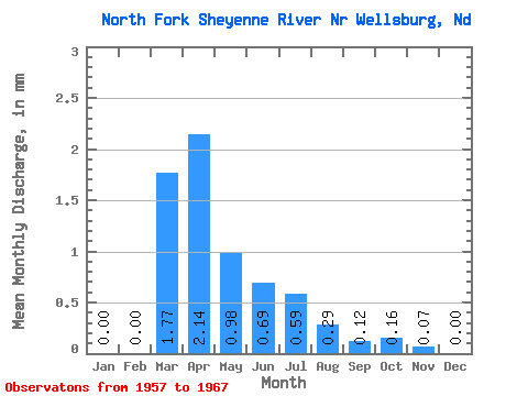
| Statistic | Jan | Feb | Mar | Apr | May | Jun | Jul | Aug | Sep | Oct | Nov | Dec | Annual |
|---|---|---|---|---|---|---|---|---|---|---|---|---|---|
| Mean | 0.00 | 0.00 | 0.53 | 0.64 | 0.29 | 0.21 | 0.18 | 0.09 | 0.04 | 0.05 | 0.02 | 0.00 | 1.80 |
| Standard Deviation | 0.00 | 0.00 | 1.09 | 0.58 | 0.33 | 0.21 | 0.29 | 0.18 | 0.11 | 0.15 | 0.05 | 0.00 | 1.85 |
| Min | 0.00 | 0.00 | 0.00 | 0.03 | 0.01 | 0.00 | 0.00 | 0.00 | 0.00 | 0.00 | 0.00 | 0.00 | 0.05 |
| Max | 0.00 | 0.01 | 3.36 | 1.74 | 1.08 | 0.60 | 0.94 | 0.50 | 0.34 | 0.46 | 0.16 | 0.01 | 5.72 |
| Coefficient of Variation | 3.09 | 2.06 | 0.91 | 1.11 | 1.01 | 1.62 | 2.11 | 3.13 | 2.95 | 2.42 | 2.69 | 1.03 |
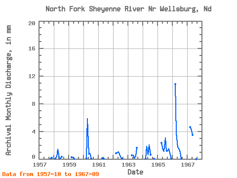
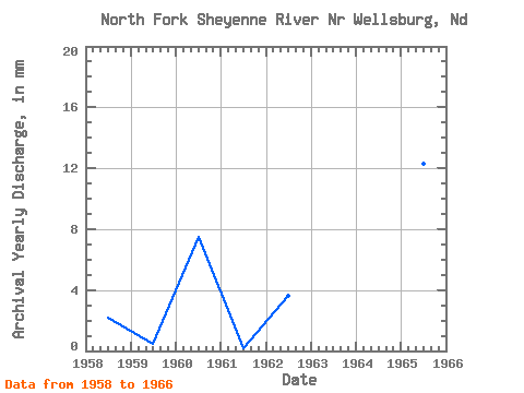
| Year | Jan | Feb | Mar | Apr | May | Jun | Jul | Aug | Sep | Oct | Nov | Dec | Annual | 1957 | 0.03 | 0.05 | 0.00 | 1958 | 0.00 | 0.01 | 0.09 | 0.41 | 0.03 | 0.00 | 0.10 | 0.00 | 0.00 | 0.00 | 0.00 | 0.00 | 0.66 | 1959 | 0.00 | 0.00 | 0.08 | 0.07 | 0.01 | 0.00 | 0.00 | 0.00 | 0.00 | 0.00 | 0.00 | 0.00 | 0.16 | 1960 | 0.00 | 0.00 | 0.04 | 1.74 | 0.20 | 0.25 | 0.01 | 0.00 | 0.00 | 0.00 | 0.00 | 0.00 | 2.26 | 1961 | 0.00 | 0.00 | 0.00 | 0.03 | 0.01 | 0.00 | 0.00 | 0.00 | 0.00 | 0.00 | 0.00 | 0.00 | 0.05 | 1962 | 0.00 | 0.00 | 0.25 | 0.28 | 0.32 | 0.20 | 0.05 | 0.00 | 0.00 | 0.00 | 0.00 | 0.00 | 1.10 | 1963 | 0.00 | 0.00 | 0.00 | 0.16 | 0.17 | 0.03 | 0.12 | 0.50 | 0.00 | 0.00 | 0.00 | 0.00 | 0.98 | 1964 | 0.00 | 0.00 | 0.02 | 0.55 | 0.19 | 0.60 | 0.19 | 0.00 | 0.00 | 0.00 | 0.00 | 0.00 | 1.57 | 1965 | 0.00 | 0.00 | 0.00 | 0.69 | 0.40 | 0.34 | 0.94 | 0.34 | 0.34 | 0.46 | 0.16 | 0.01 | 3.68 | 1966 | 0.00 | 0.00 | 3.36 | 1.12 | 0.53 | 0.45 | 0.31 | 0.01 | 0.00 | 0.00 | 0.00 | 0.00 | 5.72 | 1967 | 0.00 | 0.00 | 1.44 | 1.32 | 1.08 | 0.19 | 0.04 | 0.00 | 0.00 |
|---|
 Return to R-Arctic Net Home Page