|
|
|||||||||||||||||
| Point ID: 9582 | Downloads | Plots | Site Data | Code: 05109000 |
|
|
|||||||||||||||||
| Download | |
|---|---|
| Site Descriptor Information | Site Time Series Data |
| Link to all available data | |
|
|
| View: | Statistics | Time Series |
| Units: | m3/s |
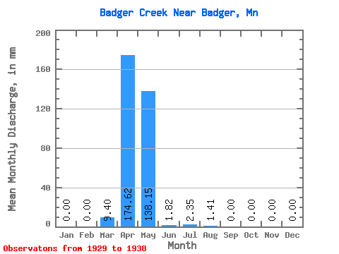
| Statistic | Jan | Feb | Mar | Apr | May | Jun | Jul | Aug | Sep | Oct | Nov | Dec | Annual |
|---|---|---|---|---|---|---|---|---|---|---|---|---|---|
| Mean | 0.00 | 0.00 | 9.42 | 174.77 | 138.26 | 1.80 | 2.56 | 1.41 | 0.00 | 0.00 | 0.00 | 0.00 | 318.10 |
| Standard Deviation | 0.00 | 0.00 | 17.24 | 153.73 | 174.34 | 3.14 | 7.67 | 4.24 | 0.00 | 0.00 | 0.00 | 0.00 | 307.37 |
| Min | 0.00 | 0.00 | 0.00 | 17.07 | 0.00 | 0.00 | 0.00 | 0.00 | 0.00 | 0.00 | 0.00 | 0.00 | 17.32 |
| Max | 0.00 | 0.00 | 49.01 | 486.86 | 424.77 | 9.97 | 23.02 | 12.72 | 0.00 | 0.00 | 0.00 | 0.00 | 867.27 |
| Coefficient of Variation | 1.83 | 0.88 | 1.26 | 1.75 | 3.00 | 3.00 | 0.97 |
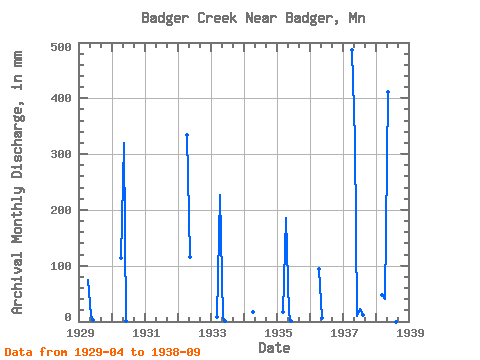
| Year | Jan | Feb | Mar | Apr | May | Jun | Jul | Aug | Sep | Oct | Nov | Dec | Annual | 1929 | 74.27 | 9.93 | 1.90 | 0.00 | 0.00 | 0.00 | 0.00 | 0.00 | 0.00 | 1930 | 0.00 | 0.00 | 0.00 | 114.70 | 329.60 | 1.00 | 0.00 | 0.00 | 0.00 | 1931 | 0.00 | 0.00 | 0.00 | 1932 | 0.00 | 0.00 | 0.00 | 334.06 | 118.71 | 0.00 | 0.00 | 0.00 | 0.00 | 0.00 | 0.00 | 0.00 | 455.55 | 1933 | 0.00 | 0.00 | 8.67 | 227.58 | 6.79 | 1.44 | 0.00 | 0.00 | 0.00 | 0.00 | 0.00 | 0.00 | 247.56 | 1934 | 0.00 | 0.00 | 0.00 | 17.07 | 0.00 | 0.00 | 0.00 | 0.00 | 0.00 | 0.00 | 0.00 | 0.00 | 17.32 | 1935 | 0.00 | 0.00 | 17.67 | 184.88 | 13.23 | 0.68 | 0.00 | 0.00 | 0.00 | 0.00 | 0.00 | 0.00 | 218.63 | 1936 | 0.00 | 0.00 | 0.00 | 93.90 | 7.14 | 0.00 | 0.00 | 0.00 | 0.00 | 0.00 | 0.00 | 0.00 | 102.29 | 1937 | 0.00 | 0.00 | 0.00 | 486.86 | 334.18 | 9.97 | 23.02 | 12.72 | 0.00 | 0.00 | 0.00 | 0.00 | 867.27 | 1938 | 0.00 | 0.00 | 49.01 | 39.59 | 424.77 | 1.18 | 0.00 | 0.00 | 0.00 |
|---|
 Return to R-Arctic Net Home Page