|
|
|||||||||||||||||
| Point ID: 9580 | Downloads | Plots | Site Data | Code: 05131455 |
|
|
|||||||||||||||||
| Download | |
|---|---|
| Site Descriptor Information | Site Time Series Data |
| Link to all available data | |

|

|
| View: | Statistics | Time Series |
| Units: | m3/s |
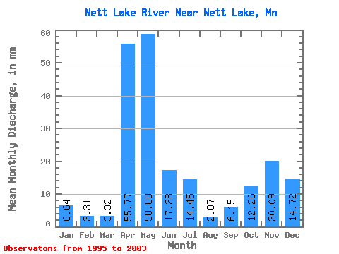
| Statistic | Jan | Feb | Mar | Apr | May | Jun | Jul | Aug | Sep | Oct | Nov | Dec | Annual |
|---|---|---|---|---|---|---|---|---|---|---|---|---|---|
| Mean | 6.64 | 3.34 | 3.32 | 55.77 | 58.87 | 17.28 | 14.45 | 2.87 | 6.15 | 12.25 | 20.09 | 14.72 | 224.92 |
| Standard Deviation | 5.29 | 2.79 | 3.62 | 35.25 | 45.45 | 15.46 | 11.35 | 5.23 | 12.52 | 13.53 | 20.51 | 11.79 | 81.70 |
| Min | 0.34 | 0.00 | 0.02 | 0.14 | 0.16 | 2.64 | 0.32 | 0.01 | 0.00 | 0.05 | 0.01 | 0.31 | 138.76 |
| Max | 12.43 | 7.77 | 9.17 | 102.76 | 117.22 | 46.82 | 32.58 | 14.56 | 34.17 | 35.08 | 46.68 | 29.18 | 308.12 |
| Coefficient of Variation | 0.80 | 0.83 | 1.09 | 0.63 | 0.77 | 0.90 | 0.79 | 1.82 | 2.04 | 1.10 | 1.02 | 0.80 | 0.36 |
| Year | Jan | Feb | Mar | Apr | May | Jun | Jul | Aug | Sep | Oct | Nov | Dec | Annual | 1995 | 35.08 | 31.97 | 17.81 | 1996 | 11.89 | 7.77 | 6.29 | 47.60 | 117.22 | 19.84 | 0.32 | 0.56 | 2.71 | 17.26 | 44.61 | 26.11 | 301.25 | 1997 | 12.43 | 5.38 | 5.37 | 82.50 | 96.11 | 5.62 | 21.68 | 0.10 | 0.02 | 0.31 | 0.22 | 3.08 | 232.05 | 1998 | 2.60 | 4.63 | 9.17 | 44.62 | 32.62 | 25.66 | 18.81 | 0.01 | 0.00 | 0.05 | 0.01 | 0.31 | 138.76 | 1999 | 0.34 | 0.30 | 0.71 | 102.76 | 89.39 | 14.35 | 17.07 | 14.56 | 34.17 | 23.70 | 6.16 | 4.97 | 308.12 | 2000 | 3.79 | 2.74 | 1.62 | 81.35 | 67.35 | 2.64 | 4.86 | 2.36 | 5.52 | 2001 | 7.41 | 46.68 | 29.18 | 2002 | 12.23 | 2.58 | 0.04 | 31.40 | 9.22 | 46.82 | 5.86 | 0.75 | 0.40 | 1.97 | 10.99 | 21.57 | 144.42 | 2003 | 3.20 | 0.00 | 0.02 | 0.14 | 0.16 | 6.04 | 32.58 | 1.71 | 0.23 |
|---|
 Return to R-Arctic Net Home Page