|
|
|||||||||||||||||
| Point ID: 9565 | Downloads | Plots | Site Data | Code: 05080000 |
|
|
|||||||||||||||||
| Download | |
|---|---|
| Site Descriptor Information | Site Time Series Data |
| Link to all available data | |
|
|
| View: | Statistics | Time Series |
| Units: | m3/s |
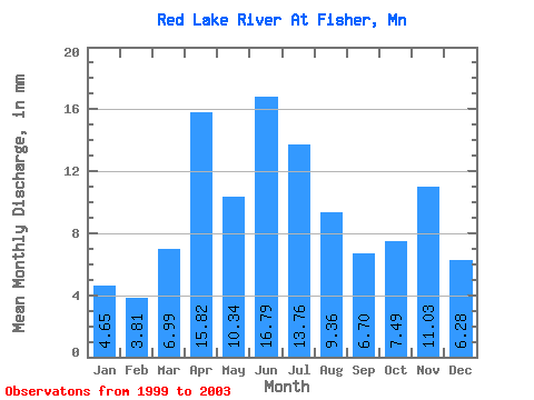
| Statistic | Jan | Feb | Mar | Apr | May | Jun | Jul | Aug | Sep | Oct | Nov | Dec | Annual |
|---|---|---|---|---|---|---|---|---|---|---|---|---|---|
| Mean | 4.64 | 3.85 | 6.99 | 15.82 | 10.33 | 16.79 | 13.76 | 9.35 | 6.70 | 7.49 | 11.03 | 6.28 | 132.30 |
| Standard Deviation | 2.19 | 1.94 | 3.21 | 16.64 | 6.34 | 10.57 | 11.16 | 7.41 | 5.76 | 2.80 | 6.73 | 2.44 | 18.56 |
| Min | 1.38 | 1.07 | 4.73 | 2.96 | 3.87 | 6.98 | 3.48 | 1.07 | 0.82 | 5.64 | 4.53 | 2.72 | 111.77 |
| Max | 6.12 | 5.20 | 11.75 | 40.23 | 18.90 | 31.80 | 29.44 | 16.43 | 14.36 | 11.66 | 20.47 | 8.16 | 147.90 |
| Coefficient of Variation | 0.47 | 0.50 | 0.46 | 1.05 | 0.61 | 0.63 | 0.81 | 0.79 | 0.86 | 0.37 | 0.61 | 0.39 | 0.14 |
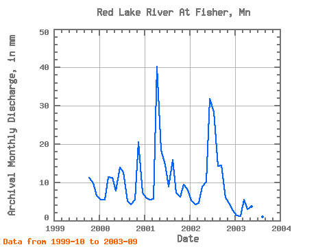
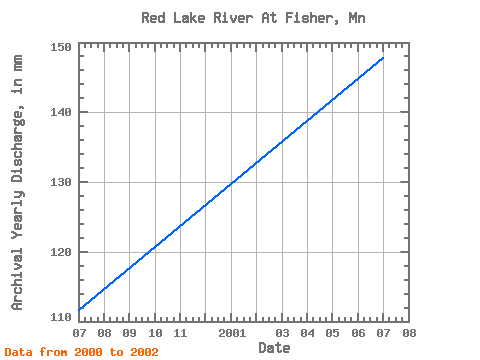
| Year | Jan | Feb | Mar | Apr | May | Jun | Jul | Aug | Sep | Oct | Nov | Dec | Annual | 1999 | 11.66 | 9.70 | 6.82 | 2000 | 5.61 | 5.18 | 11.75 | 11.28 | 8.02 | 13.82 | 12.98 | 5.19 | 4.28 | 5.64 | 20.47 | 7.44 | 111.77 | 2001 | 6.12 | 5.20 | 5.84 | 40.23 | 18.90 | 14.57 | 9.13 | 16.43 | 7.33 | 6.38 | 9.43 | 8.16 | 147.90 | 2002 | 5.47 | 3.94 | 4.73 | 8.83 | 10.55 | 31.80 | 29.44 | 14.72 | 14.36 | 6.27 | 4.53 | 2.72 | 137.23 | 2003 | 1.38 | 1.07 | 5.62 | 2.96 | 3.87 | 6.98 | 3.48 | 1.07 | 0.82 |
|---|
 Return to R-Arctic Net Home Page