|
|
|||||||||||||||||
| Point ID: 9548 | Downloads | Plots | Site Data | Code: 05078730 |
|
|
|||||||||||||||||
| Download | |
|---|---|
| Site Descriptor Information | Site Time Series Data |
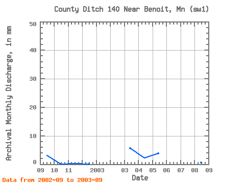
| Link to all available data | |
|
|
| View: | Statistics | Time Series |
| Units: | m3/s |
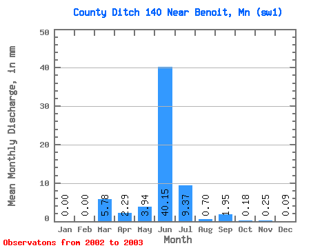
| Statistic | Jan | Feb | Mar | Apr | May | Jun | Jul | Aug | Sep | Oct | Nov | Dec | Annual |
|---|---|---|---|---|---|---|---|---|---|---|---|---|---|
| Mean | 0.00 | 0.00 | 5.76 | 2.29 | 3.98 | 40.15 | 9.36 | 0.67 | 1.96 | 0.21 | 0.28 | 0.07 | |
| Standard Deviation | 1.63 | ||||||||||||
| Min | 0.00 | 0.00 | 5.76 | 2.29 | 3.98 | 40.15 | 9.36 | 0.67 | 0.81 | 0.21 | 0.28 | 0.07 | |
| Max | 0.00 | 0.00 | 5.76 | 2.29 | 3.98 | 40.15 | 9.36 | 0.67 | 3.11 | 0.21 | 0.28 | 0.07 | |
| Coefficient of Variation | 0.83 |
| Year | Jan | Feb | Mar | Apr | May | Jun | Jul | Aug | Sep | Oct | Nov | Dec | Annual | 2002 | 3.11 | 0.21 | 0.28 | 0.07 | 2003 | 0.00 | 0.00 | 5.76 | 2.29 | 3.98 | 40.15 | 9.36 | 0.67 | 0.81 |
|---|
 Return to R-Arctic Net Home Page