|
|
|||||||||||||||||
| Point ID: 9544 | Downloads | Plots | Site Data | Code: 05079250 |
|
|
|||||||||||||||||
| Download | |
|---|---|
| Site Descriptor Information | Site Time Series Data |
| Link to all available data | |
|
|
| View: | Statistics | Time Series |
| Units: | m3/s |
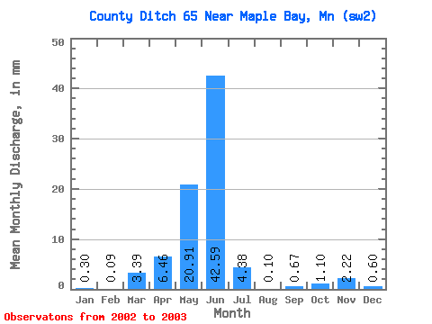
| Statistic | Jan | Feb | Mar | Apr | May | Jun | Jul | Aug | Sep | Oct | Nov | Dec | Annual |
|---|---|---|---|---|---|---|---|---|---|---|---|---|---|
| Mean | 0.27 | 0.09 | 3.41 | 6.44 | 20.91 | 42.63 | 4.38 | 0.08 | 0.65 | 1.08 | 2.20 | 0.64 | |
| Standard Deviation | 0.86 | ||||||||||||
| Min | 0.27 | 0.09 | 3.41 | 6.44 | 20.91 | 42.63 | 4.38 | 0.08 | 0.04 | 1.08 | 2.20 | 0.64 | |
| Max | 0.27 | 0.09 | 3.41 | 6.44 | 20.91 | 42.63 | 4.38 | 0.08 | 1.26 | 1.08 | 2.20 | 0.64 | |
| Coefficient of Variation | 1.32 |
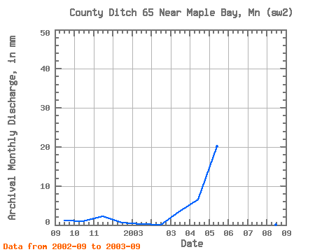
| Year | Jan | Feb | Mar | Apr | May | Jun | Jul | Aug | Sep | Oct | Nov | Dec | Annual | 2002 | 1.26 | 1.08 | 2.20 | 0.64 | 2003 | 0.27 | 0.09 | 3.41 | 6.44 | 20.91 | 42.63 | 4.38 | 0.08 | 0.04 |
|---|
 Return to R-Arctic Net Home Page