|
|
|||||||||||||||||
| Point ID: 9527 | Downloads | Plots | Site Data | Code: 15283700 |
|
|
|||||||||||||||||
| Download | |
|---|---|
| Site Descriptor Information | Site Time Series Data |
| Link to all available data | |
|
|
| View: | Statistics | Time Series |
| Units: | m3/s |
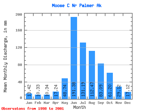
| Statistic | Jan | Feb | Mar | Apr | May | Jun | Jul | Aug | Sep | Oct | Nov | Dec | Annual |
|---|---|---|---|---|---|---|---|---|---|---|---|---|---|
| Mean | 13.42 | 10.42 | 10.33 | 17.25 | 48.74 | 191.39 | 131.16 | 112.45 | 83.09 | 61.19 | 29.11 | 17.11 | 786.23 |
| Standard Deviation | 1.58 | 1.89 | 1.68 | 4.51 | 7.28 | 39.55 | 48.61 | 16.21 | 40.58 | 6.26 | 5.66 | 2.47 | 188.63 |
| Min | 11.82 | 8.26 | 8.72 | 12.12 | 41.13 | 155.77 | 94.27 | 91.30 | 51.45 | 54.12 | 22.65 | 15.34 | 652.84 |
| Max | 14.98 | 11.72 | 12.08 | 20.61 | 55.65 | 230.54 | 202.61 | 130.06 | 141.68 | 66.04 | 33.19 | 19.93 | 919.61 |
| Coefficient of Variation | 0.12 | 0.18 | 0.16 | 0.26 | 0.15 | 0.21 | 0.37 | 0.14 | 0.49 | 0.10 | 0.20 | 0.14 | 0.24 |
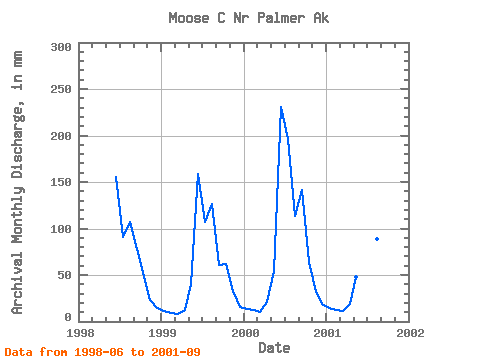
| Year | Jan | Feb | Mar | Apr | May | Jun | Jul | Aug | Sep | Oct | Nov | Dec | Annual | 1998 | 155.77 | 94.27 | 110.73 | 78.09 | 54.12 | 22.65 | 15.34 | 1999 | 11.82 | 8.26 | 8.72 | 12.12 | 41.13 | 158.92 | 110.29 | 130.06 | 61.16 | 63.40 | 33.19 | 16.08 | 652.84 | 2000 | 13.46 | 11.28 | 10.20 | 20.61 | 55.65 | 230.54 | 202.61 | 117.72 | 141.68 | 66.04 | 31.50 | 19.93 | 919.61 | 2001 | 14.98 | 11.72 | 12.08 | 19.02 | 49.42 | 220.33 | 117.46 | 91.30 | 51.45 |
|---|
 Return to R-Arctic Net Home Page