|
|
|||||||||||||||||
| Point ID: 9523 | Downloads | Plots | Site Data | Code: 15292780 |
|
|
|||||||||||||||||
| Download | |
|---|---|
| Site Descriptor Information | Site Time Series Data |
| Link to all available data | |
|
|
| View: | Statistics | Time Series |
| Units: | m3/s |
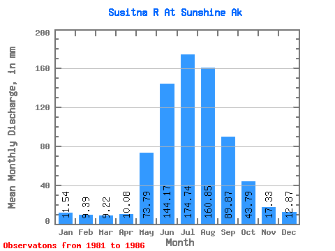
| Statistic | Jan | Feb | Mar | Apr | May | Jun | Jul | Aug | Sep | Oct | Nov | Dec | Annual |
|---|---|---|---|---|---|---|---|---|---|---|---|---|---|
| Mean | 11.54 | 9.47 | 9.22 | 10.08 | 73.78 | 144.17 | 174.71 | 160.83 | 89.87 | 43.79 | 17.33 | 12.87 | 737.81 |
| Standard Deviation | 1.97 | 1.61 | 1.79 | 1.39 | 13.19 | 15.88 | 31.12 | 38.49 | 24.81 | 8.41 | 2.32 | 1.88 | 28.06 |
| Min | 9.23 | 7.76 | 7.59 | 7.91 | 58.13 | 119.66 | 146.07 | 120.25 | 61.14 | 32.58 | 15.51 | 10.64 | 696.93 |
| Max | 13.76 | 11.21 | 11.86 | 11.62 | 95.38 | 160.39 | 225.78 | 224.06 | 124.67 | 56.28 | 21.12 | 14.80 | 760.88 |
| Coefficient of Variation | 0.17 | 0.17 | 0.19 | 0.14 | 0.18 | 0.11 | 0.18 | 0.24 | 0.28 | 0.19 | 0.13 | 0.15 | 0.04 |
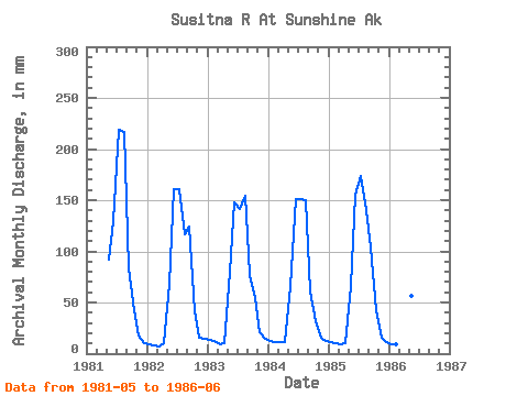
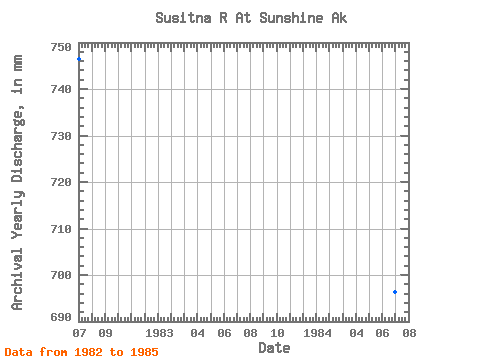
| Year | Jan | Feb | Mar | Apr | May | Jun | Jul | Aug | Sep | Oct | Nov | Dec | Annual | 1981 | 95.38 | 129.92 | 225.78 | 224.06 | 82.87 | 43.40 | 17.95 | 10.64 | 1982 | 9.23 | 7.76 | 7.59 | 9.71 | 70.06 | 160.39 | 166.25 | 120.25 | 124.67 | 42.68 | 16.08 | 14.80 | 746.92 | 1983 | 13.76 | 11.21 | 9.18 | 10.71 | 82.79 | 148.32 | 146.07 | 159.80 | 76.62 | 56.28 | 21.12 | 14.65 | 746.51 | 1984 | 12.92 | 11.05 | 11.86 | 11.62 | 68.37 | 151.34 | 155.99 | 154.90 | 61.14 | 32.58 | 15.96 | 12.87 | 696.93 | 1985 | 12.04 | 9.18 | 9.89 | 10.43 | 67.93 | 155.40 | 179.46 | 145.15 | 104.05 | 44.00 | 15.51 | 11.36 | 760.88 | 1986 | 9.75 | 8.12 | 7.59 | 7.91 | 58.13 | 119.66 |
|---|
 Return to R-Arctic Net Home Page