|
|
|||||||||||||||||
| Point ID: 9499 | Downloads | Plots | Site Data | Code: 15297100 |
|
|
|||||||||||||||||
| Download | |
|---|---|
| Site Descriptor Information | Site Time Series Data |
| Link to all available data | |
|
|
| View: | Statistics | Time Series |
| Units: | m3/s |
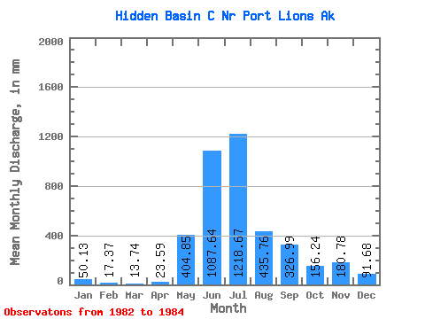
| Statistic | Jan | Feb | Mar | Apr | May | Jun | Jul | Aug | Sep | Oct | Nov | Dec | Annual |
|---|---|---|---|---|---|---|---|---|---|---|---|---|---|
| Mean | 50.28 | 17.38 | 13.80 | 23.43 | 404.87 | 1087.78 | 1218.49 | 435.61 | 326.91 | 156.07 | 180.75 | 91.61 | 4289.16 |
| Standard Deviation | 4.44 | 275.88 | 139.24 | 126.68 | 170.18 | 1.45 | |||||||
| Min | 47.14 | 17.38 | 13.80 | 23.43 | 404.87 | 1087.78 | 1218.49 | 240.53 | 228.45 | 66.50 | 60.41 | 90.58 | 4289.16 |
| Max | 53.42 | 17.38 | 13.80 | 23.43 | 404.87 | 1087.78 | 1218.49 | 630.69 | 425.36 | 245.65 | 301.08 | 92.63 | 4289.16 |
| Coefficient of Variation | 0.09 | 0.63 | 0.43 | 0.81 | 0.94 | 0.02 |
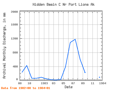
| Year | Jan | Feb | Mar | Apr | May | Jun | Jul | Aug | Sep | Oct | Nov | Dec | Annual | 1982 | 240.53 | 425.36 | 66.50 | 60.41 | 90.58 | 1983 | 47.14 | 17.38 | 13.80 | 23.43 | 404.87 | 1087.78 | 1218.49 | 630.69 | 228.45 | 245.65 | 301.08 | 92.63 | 4289.16 | 1984 | 53.42 |
|---|
 Return to R-Arctic Net Home Page