|
|
|||||||||||||||||
| Point ID: 9496 | Downloads | Plots | Site Data | Code: 15296600 |
|
|
|||||||||||||||||
| Download | |
|---|---|
| Site Descriptor Information | Site Time Series Data |
| Link to all available data | |
|
|
| View: | Statistics | Time Series |
| Units: | m3/s |
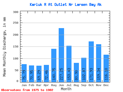
| Statistic | Jan | Feb | Mar | Apr | May | Jun | Jul | Aug | Sep | Oct | Nov | Dec | Annual |
|---|---|---|---|---|---|---|---|---|---|---|---|---|---|
| Mean | 75.78 | 71.56 | 69.27 | 72.45 | 140.72 | 227.25 | 153.41 | 80.89 | 102.86 | 171.91 | 159.34 | 116.09 | 1449.21 |
| Standard Deviation | 37.96 | 13.71 | 24.26 | 28.26 | 31.34 | 47.11 | 39.37 | 18.72 | 47.59 | 72.27 | 82.88 | 72.60 | 133.50 |
| Min | 47.95 | 52.13 | 44.72 | 35.63 | 97.13 | 177.61 | 101.46 | 52.26 | 35.66 | 70.50 | 108.98 | 45.92 | 1306.88 |
| Max | 141.99 | 85.36 | 106.19 | 112.67 | 183.91 | 295.57 | 188.76 | 108.15 | 179.29 | 263.53 | 304.62 | 229.52 | 1571.65 |
| Coefficient of Variation | 0.50 | 0.19 | 0.35 | 0.39 | 0.22 | 0.21 | 0.26 | 0.23 | 0.46 | 0.42 | 0.52 | 0.62 | 0.09 |
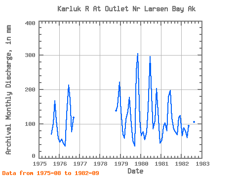
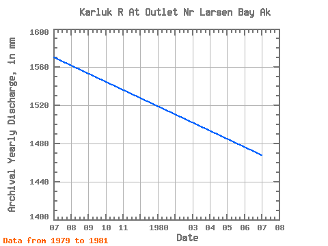
| Year | Jan | Feb | Mar | Apr | May | Jun | Jul | Aug | Sep | Oct | Nov | Dec | Annual | 1975 | 71.28 | 100.77 | 172.82 | 108.98 | 59.98 | 1976 | 47.95 | 52.13 | 44.72 | 35.63 | 131.71 | 213.05 | 174.88 | 78.53 | 117.65 | 1978 | 143.37 | 151.12 | 229.52 | 1979 | 141.99 | 64.79 | 60.55 | 112.67 | 141.02 | 177.61 | 101.46 | 52.26 | 35.66 | 263.53 | 304.62 | 116.93 | 1571.65 | 1980 | 67.17 | 72.25 | 55.09 | 74.79 | 149.84 | 295.57 | 188.76 | 88.70 | 107.81 | 209.31 | 113.99 | 45.92 | 1469.08 | 1981 | 54.32 | 85.36 | 106.19 | 79.55 | 183.91 | 197.31 | 121.15 | 86.39 | 76.01 | 70.50 | 118.01 | 128.09 | 1306.88 | 1982 | 67.45 | 83.30 | 79.82 | 59.63 | 97.13 | 252.70 | 180.79 | 108.15 | 179.29 |
|---|
 Return to R-Arctic Net Home Page