|
|
|||||||||||||||||
| Point ID: 9495 | Downloads | Plots | Site Data | Code: 15296550 |
|
|
|||||||||||||||||
| Download | |
|---|---|
| Site Descriptor Information | Site Time Series Data |
| Link to all available data | |

|

|
| View: | Statistics | Time Series |
| Units: | m3/s |
| Statistic | Jan | Feb | Mar | Apr | May | Jun | Jul | Aug | Sep | Oct | Nov | Dec | Annual |
|---|---|---|---|---|---|---|---|---|---|---|---|---|---|
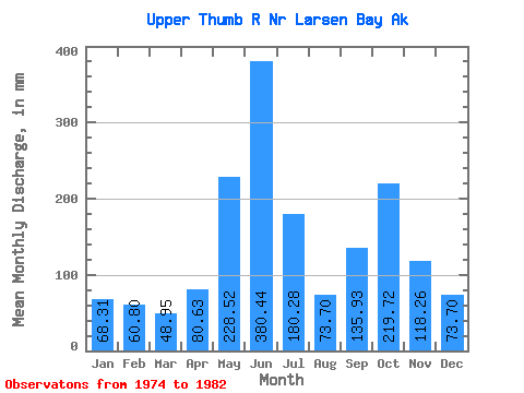
| Mean | 68.31 | 61.34 | 48.94 | 80.62 | 228.47 | 380.47 | 180.24 | 73.70 | 135.91 | 219.69 | 118.28 | 73.66 | 1706.32 |
| Standard Deviation | 49.75 | 40.76 | 24.77 | 52.66 | 55.49 | 132.55 | 80.07 | 35.11 | 61.76 | 71.26 | 77.24 | 50.38 | 248.29 |
| Min | 24.01 | 17.32 | 14.55 | 27.72 | 170.24 | 246.06 | 41.74 | 48.93 | 62.70 | 122.71 | 40.80 | 23.04 | 1419.39 |
| Max | 167.01 | 126.52 | 84.74 | 192.41 | 318.56 | 646.26 | 308.88 | 152.70 | 232.50 | 361.55 | 284.34 | 149.94 | 2020.20 |
| Coefficient of Variation | 0.73 | 0.66 | 0.51 | 0.65 | 0.24 | 0.35 | 0.44 | 0.48 | 0.45 | 0.32 | 0.65 | 0.68 | 0.15 |
| Year | Jan | Feb | Mar | Apr | May | Jun | Jul | Aug | Sep | Oct | Nov | Dec | Annual | 1974 | 41.74 | 50.38 | 132.98 | 185.55 | 84.90 | 27.72 | 1975 | 24.01 | 17.32 | 14.55 | 36.57 | 190.28 | 402.10 | 257.63 | 62.89 | 114.29 | 224.48 | 48.93 | 30.59 | 1419.39 | 1976 | 28.13 | 36.10 | 26.67 | 27.72 | 170.24 | 308.51 | 190.37 | 49.58 | 215.67 | 209.06 | 133.13 | 109.35 | 1503.34 | 1977 | 167.01 | 97.79 | 53.60 | 113.84 | 214.43 | 646.26 | 308.88 | 100.26 | 81.79 | 162.55 | 40.80 | 23.04 | 2012.34 | 1978 | 25.81 | 32.88 | 30.84 | 67.02 | 318.56 | 483.75 | 230.19 | 152.70 | 178.29 | 239.24 | 116.55 | 149.94 | 2020.20 | 1979 | 104.69 | 23.41 | 65.35 | 192.41 | 245.28 | 257.42 | 114.82 | 49.43 | 70.63 | 361.55 | 284.34 | 69.93 | 1834.76 | 1980 | 41.95 | 60.37 | 41.19 | 58.73 | 197.86 | 371.55 | 190.10 | 48.93 | 134.38 | 252.41 | 86.86 | 46.72 | 1530.63 | 1981 | 74.44 | 126.52 | 84.74 | 87.16 | 302.94 | 246.06 | 142.92 | 89.87 | 62.70 | 122.71 | 150.71 | 132.01 | 1623.60 | 1982 | 80.42 | 96.37 | 74.54 | 61.49 | 188.16 | 328.10 | 145.50 | 59.27 | 232.50 |
|---|
 Return to R-Arctic Net Home Page