|
|
|||||||||||||||||
| Point ID: 9493 | Downloads | Plots | Site Data | Code: 15296500 |
|
|
|||||||||||||||||
| Download | |
|---|---|
| Site Descriptor Information | Site Time Series Data |
| Link to all available data | |
|
|
| View: | Statistics | Time Series |
| Units: | m3/s |
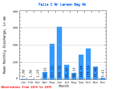
| Statistic | Jan | Feb | Mar | Apr | May | Jun | Jul | Aug | Sep | Oct | Nov | Dec | Annual |
|---|---|---|---|---|---|---|---|---|---|---|---|---|---|
| Mean | 4.02 | 2.00 | 1.09 | 44.17 | 207.26 | 306.31 | 85.32 | 38.16 | 143.50 | 179.48 | 75.42 | 9.34 | |
| Standard Deviation | 97.88 | 13.44 | 35.30 | ||||||||||
| Min | 4.02 | 2.00 | 1.09 | 44.17 | 207.26 | 306.31 | 16.10 | 28.66 | 118.54 | 179.48 | 75.42 | 9.34 | |
| Max | 4.02 | 2.00 | 1.09 | 44.17 | 207.26 | 306.31 | 154.53 | 47.66 | 168.46 | 179.48 | 75.42 | 9.34 | |
| Coefficient of Variation | 1.15 | 0.35 | 0.25 |
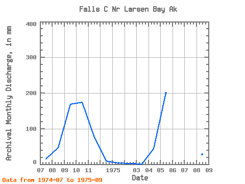
| Year | Jan | Feb | Mar | Apr | May | Jun | Jul | Aug | Sep | Oct | Nov | Dec | Annual | 1974 | 16.10 | 47.66 | 168.46 | 179.48 | 75.42 | 9.34 | 1975 | 4.02 | 2.00 | 1.09 | 44.17 | 207.26 | 306.31 | 154.53 | 28.66 | 118.54 |
|---|
 Return to R-Arctic Net Home Page