|
|
|||||||||||||||||
| Point ID: 9488 | Downloads | Plots | Site Data | Code: 15295600 |
|
|
|||||||||||||||||
| Download | |
|---|---|
| Site Descriptor Information | Site Time Series Data |
| Link to all available data | |

|

|
| View: | Statistics | Time Series |
| Units: | m3/s |
| Statistic | Jan | Feb | Mar | Apr | May | Jun | Jul | Aug | Sep | Oct | Nov | Dec | Annual |
|---|---|---|---|---|---|---|---|---|---|---|---|---|---|
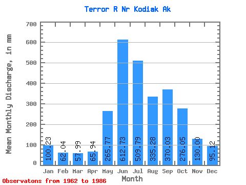
| Mean | 100.21 | 62.60 | 57.98 | 65.92 | 265.73 | 612.75 | 509.74 | 335.20 | 370.06 | 276.04 | 129.98 | 95.08 | 2940.05 |
| Standard Deviation | 106.22 | 39.80 | 32.49 | 45.19 | 165.15 | 345.30 | 306.06 | 170.71 | 145.50 | 176.01 | 80.08 | 77.31 | 903.55 |
| Min | 30.95 | 20.08 | 17.97 | 25.16 | 35.97 | 1.02 | 1.59 | 41.41 | 153.42 | 105.29 | 43.82 | 31.14 | 1205.43 |
| Max | 421.72 | 136.38 | 116.32 | 187.09 | 557.77 | 1018.16 | 1016.61 | 627.38 | 629.74 | 746.91 | 316.67 | 279.79 | 4255.64 |
| Coefficient of Variation | 1.06 | 0.64 | 0.56 | 0.69 | 0.62 | 0.56 | 0.60 | 0.51 | 0.39 | 0.64 | 0.62 | 0.81 | 0.31 |
| Year | Jan | Feb | Mar | Apr | May | Jun | Jul | Aug | Sep | Oct | Nov | Dec | Annual | 1962 | 687.72 | 365.39 | 146.60 | 223.47 | 129.68 | 316.67 | 107.49 | 1963 | 421.72 | 71.25 | 50.80 | 44.26 | 203.77 | 492.47 | 373.12 | 419.89 | 483.14 | 200.36 | 46.85 | 99.37 | 2896.48 | 1964 | 42.43 | 28.98 | 24.53 | 34.30 | 122.06 | 848.79 | 636.92 | 627.38 | 306.39 | 215.12 | 64.82 | 34.55 | 2976.37 | 1965 | 32.03 | 20.08 | 103.58 | 74.34 | 266.81 | 588.82 | 707.94 | 295.69 | 517.75 | 335.98 | 43.82 | 31.14 | 3005.72 | 1966 | 49.10 | 25.43 | 17.97 | 25.16 | 74.15 | 1008.78 | 704.63 | 400.60 | 552.88 | 224.44 | 57.26 | 42.37 | 3181.70 | 1967 | 30.95 | 20.86 | 27.23 | 85.44 | 371.91 | 661.08 | 253.31 | 277.47 | 629.74 | 146.96 | 133.49 | 100.06 | 2740.62 | 1968 | 51.13 | 88.24 | 58.56 | 51.59 | 394.42 | 701.50 | 669.57 | 503.36 | 242.78 | 1978 | 791.18 | 554.75 | 494.30 | 355.13 | 66.02 | 36.94 | 1979 | 67.66 | 23.33 | 34.23 | 64.76 | 386.35 | 775.40 | 649.28 | 485.78 | 441.84 | 746.91 | 207.45 | 60.84 | 3923.89 | 1980 | 44.76 | 40.52 | 32.30 | 31.22 | 239.39 | 924.03 | 643.20 | 260.13 | 463.46 | 544.98 | 85.82 | 59.26 | 3361.59 | 1981 | 171.62 | 123.63 | 73.39 | 42.76 | 557.77 | 694.37 | 682.82 | 379.79 | 361.31 | 162.60 | 168.43 | 90.47 | 3499.15 | 1982 | 33.61 | 110.40 | 26.21 | 26.16 | 181.00 | 773.08 | 642.44 | 224.01 | 375.06 | 105.29 | 176.37 | 254.33 | 2930.07 | 1983 | 125.47 | 48.09 | 71.88 | 69.05 | 556.20 | 1018.16 | 1016.61 | 464.97 | 153.42 | 255.84 | 220.64 | 279.79 | 4255.64 | 1984 | 195.31 | 136.38 | 116.32 | 53.10 | 35.97 | 1.02 | 9.87 | 171.23 | 205.18 | 214.61 | 102.67 | 60.79 | 1303.96 | 1985 | 60.28 | 69.97 | 95.52 | 133.62 | 149.78 | 1.30 | 1.59 | 41.41 | 221.31 | 226.63 | 129.39 | 73.71 | 1205.43 | 1986 | 76.93 | 69.20 | 79.26 | 187.09 | 180.63 | 14.73 | 8.01 | 110.12 | 248.89 |
|---|
 Return to R-Arctic Net Home Page