|
|
|||||||||||||||||
| Point ID: 9471 | Downloads | Plots | Site Data | Code: 15246000 |
|
|
|||||||||||||||||
| Download | |
|---|---|
| Site Descriptor Information | Site Time Series Data |
| Link to all available data | |

|

|
| View: | Statistics | Time Series |
| Units: | m3/s |
| Statistic | Jan | Feb | Mar | Apr | May | Jun | Jul | Aug | Sep | Oct | Nov | Dec | Annual |
|---|---|---|---|---|---|---|---|---|---|---|---|---|---|
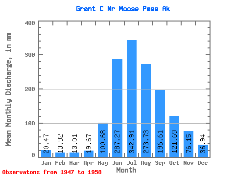
| Mean | 20.47 | 14.05 | 12.99 | 19.68 | 100.65 | 287.27 | 342.86 | 273.70 | 196.60 | 121.66 | 76.16 | 36.93 | 1488.35 |
| Standard Deviation | 8.87 | 5.63 | 3.85 | 10.91 | 43.45 | 114.76 | 66.68 | 35.86 | 85.29 | 60.08 | 50.02 | 23.51 | 270.03 |
| Min | 9.91 | 7.45 | 9.03 | 9.29 | 43.80 | 172.37 | 237.49 | 215.37 | 99.47 | 42.81 | 21.32 | 13.92 | 1154.34 |
| Max | 38.22 | 26.83 | 20.14 | 42.05 | 186.13 | 595.12 | 471.14 | 339.84 | 362.13 | 223.12 | 168.44 | 82.41 | 2138.24 |
| Coefficient of Variation | 0.43 | 0.40 | 0.30 | 0.55 | 0.43 | 0.40 | 0.19 | 0.13 | 0.43 | 0.49 | 0.66 | 0.64 | 0.18 |
| Year | Jan | Feb | Mar | Apr | May | Jun | Jul | Aug | Sep | Oct | Nov | Dec | Annual | 1947 | 166.81 | 173.84 | 128.01 | 76.97 | 1948 | 21.45 | 14.54 | 10.89 | 17.37 | 161.88 | 315.83 | 368.28 | 255.15 | 103.95 | 171.83 | 57.55 | 17.14 | 1506.22 | 1949 | 9.91 | 7.45 | 9.78 | 10.98 | 90.99 | 262.16 | 313.99 | 215.37 | 285.57 | 128.55 | 126.09 | 47.21 | 1504.06 | 1950 | 24.63 | 12.76 | 12.11 | 16.71 | 77.78 | 286.22 | 344.75 | 318.44 | 216.37 | 67.17 | 21.32 | 13.92 | 1405.69 | 1951 | 12.63 | 9.38 | 9.03 | 17.53 | 82.34 | 208.59 | 343.37 | 249.04 | 323.72 | 58.16 | 33.02 | 20.10 | 1362.28 | 1952 | 12.21 | 9.94 | 10.40 | 9.29 | 43.80 | 240.30 | 378.90 | 287.40 | 171.60 | 223.12 | 168.44 | 82.41 | 1628.62 | 1953 | 38.22 | 26.83 | 20.14 | 39.36 | 186.13 | 595.12 | 471.14 | 339.84 | 188.16 | 170.34 | 44.27 | 26.32 | 2138.24 | 1954 | 21.26 | 20.09 | 18.80 | 19.06 | 114.41 | 262.44 | 277.83 | 254.15 | 128.76 | 111.44 | 93.23 | 34.01 | 1349.51 | 1955 | 27.56 | 14.33 | 11.93 | 11.54 | 47.69 | 186.34 | 425.93 | 269.70 | 175.00 | 53.98 | 26.90 | 16.56 | 1259.16 | 1956 | 13.24 | 10.25 | 9.94 | 14.06 | 80.01 | 172.37 | 312.07 | 300.10 | 137.65 | 42.81 | 35.66 | 34.29 | 1154.34 | 1957 | 14.82 | 11.46 | 12.99 | 18.55 | 109.64 | 287.86 | 237.49 | 244.77 | 362.13 | 137.05 | 103.31 | 37.28 | 1575.34 | 1958 | 29.23 | 17.55 | 16.90 | 42.05 | 112.53 | 342.75 | 297.67 | 276.73 | 99.47 |
|---|
 Return to R-Arctic Net Home Page