|
|
|||||||||||||||||
| Point ID: 9470 | Downloads | Plots | Site Data | Code: 15244000 |
|
|
|||||||||||||||||
| Download | |
|---|---|
| Site Descriptor Information | Site Time Series Data |
| Link to all available data | |
|
|
| View: | Statistics | Time Series |
| Units: | m3/s |
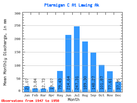
| Statistic | Jan | Feb | Mar | Apr | May | Jun | Jul | Aug | Sep | Oct | Nov | Dec | Annual |
|---|---|---|---|---|---|---|---|---|---|---|---|---|---|
| Mean | 21.08 | 13.97 | 12.72 | 19.07 | 79.41 | 214.63 | 247.26 | 189.27 | 148.27 | 101.84 | 77.61 | 37.96 | 1149.89 |
| Standard Deviation | 8.32 | 4.29 | 2.85 | 7.61 | 33.61 | 87.51 | 56.94 | 27.34 | 69.86 | 46.16 | 49.16 | 21.98 | 225.22 |
| Min | 11.16 | 8.18 | 8.55 | 8.26 | 28.20 | 135.02 | 157.41 | 145.55 | 90.33 | 42.38 | 26.35 | 14.79 | 898.71 |
| Max | 37.30 | 23.54 | 17.95 | 34.38 | 142.19 | 444.50 | 342.49 | 232.22 | 306.03 | 177.52 | 160.59 | 78.22 | 1572.76 |
| Coefficient of Variation | 0.40 | 0.31 | 0.22 | 0.40 | 0.42 | 0.41 | 0.23 | 0.14 | 0.47 | 0.45 | 0.63 | 0.58 | 0.20 |
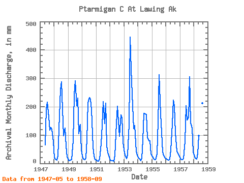
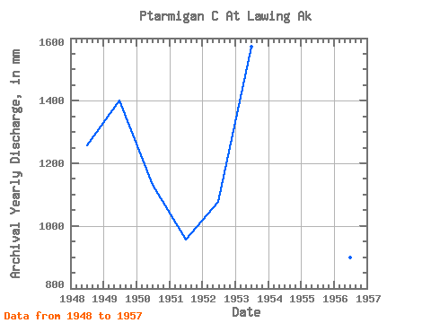
| Year | Jan | Feb | Mar | Apr | May | Jun | Jul | Aug | Sep | Oct | Nov | Dec | Annual | 1947 | 67.02 | 190.91 | 222.27 | 169.47 | 117.49 | 129.62 | 119.03 | 78.22 | 1948 | 20.81 | 13.89 | 11.82 | 25.80 | 124.98 | 261.62 | 297.50 | 196.91 | 98.09 | 129.03 | 61.83 | 22.35 | 1257.88 | 1949 | 12.55 | 9.29 | 12.35 | 14.09 | 84.28 | 240.31 | 300.55 | 209.61 | 230.05 | 107.50 | 136.41 | 49.97 | 1402.85 | 1950 | 26.99 | 13.89 | 13.33 | 18.72 | 85.99 | 213.29 | 240.61 | 232.22 | 191.52 | 59.30 | 26.35 | 14.79 | 1132.63 | 1951 | 11.16 | 8.18 | 8.55 | 17.10 | 71.27 | 135.02 | 225.79 | 145.55 | 213.06 | 64.23 | 38.70 | 22.38 | 957.70 | 1952 | 12.09 | 9.83 | 9.32 | 8.26 | 28.20 | 140.85 | 208.34 | 154.37 | 95.51 | 177.52 | 160.59 | 76.83 | 1076.48 | 1953 | 37.30 | 23.54 | 17.95 | 28.72 | 142.19 | 444.50 | 342.49 | 209.05 | 123.00 | 137.64 | 42.84 | 28.75 | 1572.76 | 1954 | 20.66 | 15.22 | 9.86 | 17.16 | 83.39 | 177.26 | 180.54 | 178.27 | 90.33 | 82.52 | 80.12 | 34.35 | 965.63 | 1955 | 24.99 | 16.36 | 14.31 | 12.99 | 33.62 | 148.19 | 322.79 | 178.85 | 108.76 | 42.38 | 27.25 | 18.88 | 943.62 | 1956 | 16.98 | 13.10 | 12.56 | 14.90 | 49.39 | 138.59 | 230.36 | 210.50 | 108.88 | 42.66 | 35.80 | 30.21 | 898.71 | 1957 | 17.41 | 13.10 | 13.65 | 17.59 | 81.12 | 203.56 | 157.41 | 167.96 | 306.03 | 147.88 | 124.74 | 40.84 | 1290.64 | 1958 | 30.94 | 17.25 | 16.18 | 34.38 | 101.44 | 281.47 | 238.54 | 218.51 | 96.53 |
|---|
 Return to R-Arctic Net Home Page