|
|
|||||||||||||||||
| Point ID: 9468 | Downloads | Plots | Site Data | Code: 15243500 |
|
|
|||||||||||||||||
| Download | |
|---|---|
| Site Descriptor Information | Site Time Series Data |
| Link to all available data | |
|
|
| View: | Statistics | Time Series |
| Units: | m3/s |
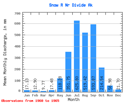
| Statistic | Jan | Feb | Mar | Apr | May | Jun | Jul | Aug | Sep | Oct | Nov | Dec | Annual |
|---|---|---|---|---|---|---|---|---|---|---|---|---|---|
| Mean | 17.13 | 13.01 | 9.77 | 17.47 | 118.26 | 351.75 | 625.71 | 519.35 | 593.88 | 214.50 | 56.99 | 21.70 | 2517.83 |
| Standard Deviation | 11.41 | 8.16 | 4.84 | 9.95 | 58.60 | 80.47 | 61.52 | 45.45 | 334.02 | 144.38 | 32.05 | 7.39 | 567.58 |
| Min | 10.27 | 6.42 | 5.86 | 9.47 | 46.07 | 221.31 | 561.54 | 477.89 | 209.82 | 48.28 | 26.72 | 13.30 | 1966.25 |
| Max | 37.28 | 26.42 | 17.68 | 33.88 | 209.14 | 443.15 | 713.27 | 579.14 | 976.59 | 370.23 | 101.36 | 32.27 | 3124.77 |
| Coefficient of Variation | 0.67 | 0.63 | 0.50 | 0.57 | 0.50 | 0.23 | 0.10 | 0.09 | 0.56 | 0.67 | 0.56 | 0.34 | 0.23 |
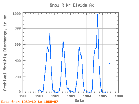
| Year | Jan | Feb | Mar | Apr | May | Jun | Jul | Aug | Sep | Oct | Nov | Dec | Annual | 1960 | 32.27 | 1961 | 37.28 | 26.42 | 17.68 | 18.02 | 209.14 | 362.44 | 591.64 | 529.36 | 737.29 | 292.54 | 42.95 | 19.00 | 2872.44 | 1962 | 10.27 | 6.42 | 5.86 | 16.36 | 103.69 | 362.72 | 663.74 | 477.89 | 209.82 | 48.28 | 56.91 | 18.14 | 1966.25 | 1963 | 12.65 | 15.03 | 10.60 | 9.65 | 111.48 | 221.31 | 598.35 | 491.00 | 451.82 | 146.96 | 26.72 | 25.76 | 2107.86 | 1964 | 14.72 | 8.59 | 6.02 | 9.47 | 46.07 | 443.15 | 561.54 | 579.14 | 976.59 | 370.23 | 101.36 | 13.30 | 3124.77 | 1965 | 10.70 | 8.60 | 8.67 | 33.88 | 120.94 | 369.12 | 713.27 |
|---|
 Return to R-Arctic Net Home Page