|
|
|||||||||||||||||
| Point ID: 9465 | Downloads | Plots | Site Data | Code: 15266150 |
|
|
|||||||||||||||||
| Download | |
|---|---|
| Site Descriptor Information | Site Time Series Data |
| Link to all available data | |
|
|
| View: | Statistics | Time Series |
| Units: | m3/s |
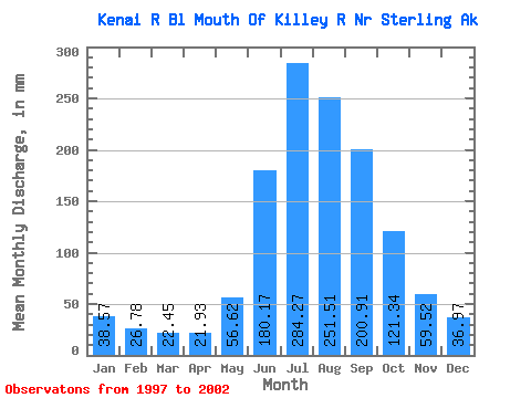
| Statistic | Jan | Feb | Mar | Apr | May | Jun | Jul | Aug | Sep | Oct | Nov | Dec | Annual |
|---|---|---|---|---|---|---|---|---|---|---|---|---|---|
| Mean | 38.56 | 27.01 | 22.44 | 21.93 | 56.61 | 180.17 | 284.23 | 251.47 | 200.91 | 121.32 | 59.52 | 36.96 | 1278.89 |
| Standard Deviation | 16.31 | 9.64 | 3.54 | 4.76 | 10.86 | 30.25 | 39.55 | 34.05 | 54.53 | 25.30 | 16.97 | 6.01 | 191.73 |
| Min | 22.03 | 17.64 | 18.12 | 15.15 | 48.07 | 145.89 | 246.29 | 215.71 | 117.37 | 83.98 | 40.52 | 31.95 | 1093.81 |
| Max | 61.46 | 41.68 | 27.38 | 28.23 | 74.83 | 209.83 | 357.03 | 311.69 | 269.81 | 153.81 | 84.32 | 44.55 | 1547.81 |
| Coefficient of Variation | 0.42 | 0.36 | 0.16 | 0.22 | 0.19 | 0.17 | 0.14 | 0.14 | 0.27 | 0.21 | 0.28 | 0.16 | 0.15 |
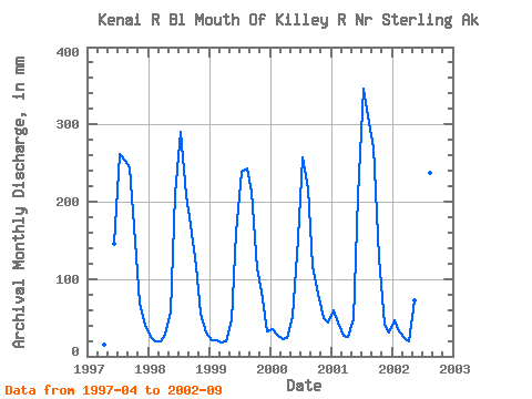
| Year | Jan | Feb | Mar | Apr | May | Jun | Jul | Aug | Sep | Oct | Nov | Dec | Annual | 1997 | 15.15 | 145.89 | 270.47 | 260.94 | 244.93 | 153.81 | 67.51 | 42.34 | 1998 | 25.57 | 17.64 | 20.16 | 28.23 | 57.96 | 209.83 | 299.51 | 215.71 | 169.62 | 120.52 | 55.53 | 32.21 | 1246.83 | 1999 | 22.03 | 19.43 | 18.12 | 19.14 | 48.07 | 159.96 | 246.29 | 251.02 | 212.37 | 117.34 | 84.32 | 33.74 | 1227.12 | 2000 | 35.73 | 26.05 | 22.81 | 24.06 | 52.62 | 152.78 | 266.36 | 223.77 | 117.37 | 83.98 | 49.73 | 44.55 | 1093.81 | 2001 | 61.46 | 41.68 | 27.38 | 25.22 | 49.58 | 206.71 | 357.03 | 311.69 | 269.81 | 130.97 | 40.52 | 31.95 | 1547.81 | 2002 | 48.02 | 30.25 | 23.76 | 19.77 | 74.83 | 205.82 | 265.73 | 245.72 | 191.38 |
|---|
 Return to R-Arctic Net Home Page