|
|
|||||||||||||||||
| Point ID: 9457 | Downloads | Plots | Site Data | Code: 15239000 |
|
|
|||||||||||||||||
| Download | |
|---|---|
| Site Descriptor Information | Site Time Series Data |
| Link to all available data | |

|

|
| View: | Statistics | Time Series |
| Units: | m3/s |
| Statistic | Jan | Feb | Mar | Apr | May | Jun | Jul | Aug | Sep | Oct | Nov | Dec | Annual |
|---|---|---|---|---|---|---|---|---|---|---|---|---|---|
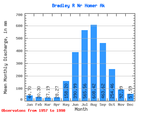
| Mean | 44.69 | 30.57 | 27.19 | 28.27 | 158.17 | 390.99 | 565.47 | 608.33 | 463.62 | 254.42 | 92.38 | 57.57 | 2677.97 |
| Standard Deviation | 35.63 | 25.66 | 21.85 | 25.80 | 81.87 | 95.71 | 105.29 | 171.57 | 206.84 | 170.85 | 58.31 | 40.84 | 524.30 |
| Min | 16.53 | 9.48 | 8.92 | 8.35 | 45.36 | 261.26 | 411.39 | 342.61 | 154.42 | 83.51 | 32.19 | 19.03 | 1753.06 |
| Max | 169.97 | 145.48 | 92.93 | 156.56 | 411.51 | 685.87 | 862.82 | 1069.23 | 898.90 | 797.85 | 253.34 | 206.67 | 3708.25 |
| Coefficient of Variation | 0.80 | 0.84 | 0.80 | 0.91 | 0.52 | 0.24 | 0.19 | 0.28 | 0.45 | 0.67 | 0.63 | 0.71 | 0.20 |
| Year | Jan | Feb | Mar | Apr | May | Jun | Jul | Aug | Sep | Oct | Nov | Dec | Annual | 1957 | 347.76 | 253.34 | 58.05 | 1958 | 41.18 | 19.77 | 16.70 | 37.38 | 203.21 | 563.57 | 585.38 | 719.06 | 179.38 | 121.77 | 51.68 | 31.06 | 2553.07 | 1959 | 16.94 | 11.89 | 11.48 | 16.67 | 160.88 | 412.75 | 411.39 | 404.20 | 154.42 | 83.51 | 47.49 | 31.31 | 1753.06 | 1960 | 20.35 | 16.64 | 12.53 | 16.66 | 309.52 | 363.06 | 472.92 | 448.23 | 229.84 | 111.81 | 72.54 | 93.35 | 2152.42 | 1961 | 104.04 | 50.78 | 21.80 | 15.32 | 227.80 | 376.94 | 558.27 | 472.73 | 522.79 | 156.57 | 58.38 | 37.28 | 2592.63 | 1962 | 28.70 | 14.74 | 11.48 | 19.69 | 92.43 | 337.96 | 441.14 | 342.61 | 208.45 | 119.82 | 160.35 | 66.35 | 1835.76 | 1963 | 58.94 | 41.38 | 34.96 | 22.73 | 123.52 | 315.44 | 625.95 | 610.75 | 497.58 | 252.52 | 47.25 | 56.18 | 2671.77 | 1964 | 38.92 | 29.99 | 20.96 | 16.47 | 45.36 | 326.83 | 503.51 | 664.84 | 465.51 | 214.50 | 70.71 | 44.36 | 2429.72 | 1965 | 33.31 | 23.78 | 28.70 | 37.89 | 68.43 | 266.01 | 469.67 | 503.75 | 724.96 | 267.52 | 83.34 | 36.53 | 2536.81 | 1966 | 20.35 | 15.21 | 16.18 | 20.71 | 78.32 | 384.92 | 462.28 | 836.07 | 763.64 | 236.57 | 32.19 | 22.59 | 2877.88 | 1967 | 18.18 | 14.59 | 15.29 | 17.99 | 131.91 | 356.68 | 495.55 | 641.13 | 752.12 | 103.22 | 113.22 | 70.80 | 2723.54 | 1968 | 51.60 | 43.21 | 55.05 | 31.45 | 160.28 | 284.85 | 455.20 | 513.55 | 206.16 | 125.12 | 36.84 | 21.18 | 1971.30 | 1969 | 18.02 | 16.17 | 17.95 | 21.72 | 161.84 | 685.87 | 640.93 | 435.25 | 289.46 | 797.85 | 106.42 | 124.72 | 3294.26 | 1970 | 61.67 | 55.37 | 56.82 | 52.20 | 172.90 | 356.12 | 547.16 | 585.79 | 306.00 | 102.77 | 192.73 | 39.53 | 2518.58 | 1971 | 23.67 | 17.02 | 15.92 | 15.68 | 60.04 | 323.76 | 727.30 | 658.52 | 255.85 | 196.15 | 54.47 | 28.59 | 2357.16 | 1972 | 16.57 | 9.48 | 8.92 | 8.35 | 73.83 | 261.26 | 611.63 | 718.95 | 514.98 | 215.50 | 62.13 | 29.28 | 2513.98 | 1973 | 17.95 | 12.46 | 12.53 | 14.06 | 66.67 | 302.91 | 479.35 | 454.28 | 458.77 | 299.84 | 87.31 | 26.01 | 2221.45 | 1974 | 16.53 | 10.90 | 10.12 | 11.45 | 118.35 | 278.45 | 448.64 | 522.06 | 758.29 | 180.81 | 113.00 | 58.67 | 2520.86 | 1975 | 28.84 | 20.48 | 17.84 | 15.20 | 185.14 | 522.99 | 557.51 | 450.75 | 429.29 | 221.31 | 59.56 | 27.12 | 2526.00 | 1976 | 20.13 | 15.29 | 13.30 | 20.77 | 107.46 | 410.85 | 577.70 | 601.65 | 653.05 | 219.12 | 209.16 | 162.75 | 3000.88 | 1977 | 169.97 | 145.48 | 92.93 | 59.98 | 184.87 | 502.70 | 862.82 | 1069.23 | 326.41 | 212.63 | 35.36 | 19.03 | 3659.49 | 1978 | 17.68 | 19.03 | 22.09 | 28.19 | 151.69 | 381.15 | 564.33 | 617.04 | 484.63 | 298.41 | 81.08 | 54.43 | 2704.59 | 1979 | 22.48 | 14.04 | 14.04 | 15.86 | 151.15 | 359.41 | 523.91 | 982.53 | 685.34 | 612.18 | 207.61 | 44.28 | 3610.39 | 1980 | 35.13 | 38.54 | 38.72 | 29.51 | 170.18 | 472.81 | 694.99 | 680.43 | 453.03 | 406.82 | 75.52 | 57.41 | 3133.85 | 1981 | 121.64 | 75.92 | 88.91 | 156.56 | 411.51 | 458.82 | 777.82 | 857.35 | 447.10 | 155.61 | 126.62 | 51.21 | 3708.25 | 1982 | 26.85 | 34.88 | 23.54 | 18.67 | 72.06 | 342.18 | 577.70 | 471.63 | 898.90 | 133.52 | 58.85 | 76.22 | 2732.29 | 1983 | 64.13 | 32.27 | 24.55 | 24.18 | 176.12 | 392.28 | 465.49 | 380.84 | 203.00 | 161.69 | 154.31 | 99.97 | 2168.05 | 1984 | 40.20 | 27.40 | 73.65 | 37.04 | 132.46 | 344.83 | 449.16 | 528.87 | 286.64 | 216.98 | 46.32 | 49.26 | 2218.71 | 1985 | 96.27 | 44.29 | 17.78 | 15.73 | 98.91 | 310.27 | 510.13 | 415.40 | 328.95 | 154.84 | 32.33 | 42.80 | 2057.28 | 1986 | 33.50 | 30.06 | 26.93 | 19.00 | 140.98 | 356.83 | 663.93 | 741.74 | 449.43 | 737.57 | 145.15 | 206.67 | 3522.64 | 1987 | 84.38 | 42.85 | 21.90 | 26.64 | 299.42 | 512.72 | 676.02 | 570.61 | 452.75 | 392.67 | 73.03 | 30.81 | 3165.53 | 1988 | 69.62 | 27.23 | 22.53 | 17.51 | 184.45 | 490.95 | 605.38 | 693.46 | 427.18 | 226.94 | 47.15 | 40.66 | 2836.55 | 1989 | 26.86 | 13.45 | 11.58 | 28.32 | 191.45 | 354.42 | 591.81 | 720.06 | 777.06 | 311.98 | 53.16 | 61.47 | 3126.12 | 1990 | 30.14 | 24.22 | 19.46 | 43.24 | 306.48 | 491.94 | 625.63 | 761.47 | 708.60 |
|---|
 Return to R-Arctic Net Home Page