|
|
|||||||||||||||||
| Point ID: 9443 | Downloads | Plots | Site Data | Code: 15264000 |
|
|
|||||||||||||||||
| Download | |
|---|---|
| Site Descriptor Information | Site Time Series Data |
| Link to all available data | |
|
|
| View: | Statistics | Time Series |
| Units: | m3/s |
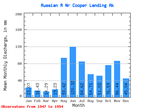
| Statistic | Jan | Feb | Mar | Apr | May | Jun | Jul | Aug | Sep | Oct | Nov | Dec | Annual |
|---|---|---|---|---|---|---|---|---|---|---|---|---|---|
| Mean | 23.06 | 16.57 | 14.28 | 19.24 | 93.41 | 120.32 | 84.61 | 54.69 | 51.04 | 76.58 | 86.43 | 45.03 | 674.87 |
| Standard Deviation | 16.73 | 10.06 | 5.75 | 9.14 | 49.86 | 53.63 | 33.46 | 26.19 | 22.67 | 46.09 | 71.49 | 37.60 | 241.91 |
| Min | 11.35 | 8.55 | 8.53 | 9.40 | 29.45 | 79.71 | 57.81 | 29.76 | 21.61 | 39.75 | 18.38 | 12.77 | 467.81 |
| Max | 58.28 | 36.56 | 25.91 | 37.55 | 169.50 | 248.89 | 164.24 | 113.05 | 77.77 | 165.35 | 212.99 | 109.40 | 1099.07 |
| Coefficient of Variation | 0.72 | 0.61 | 0.40 | 0.47 | 0.53 | 0.45 | 0.40 | 0.48 | 0.44 | 0.60 | 0.83 | 0.83 | 0.36 |
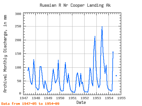
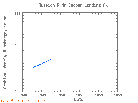
| Year | Jan | Feb | Mar | Apr | May | Jun | Jul | Aug | Sep | Oct | Nov | Dec | Annual | 1947 | 90.44 | 99.04 | 65.17 | 46.57 | 36.68 | 64.92 | 128.90 | 81.41 | 1948 | 28.37 | 22.11 | 16.88 | 23.49 | 105.70 | 102.64 | 78.67 | 43.27 | 21.61 | 52.26 | 36.94 | 19.02 | 549.23 | 1949 | 12.03 | 8.55 | 12.38 | 16.58 | 54.79 | 94.29 | 73.72 | 44.04 | 47.63 | 61.97 | 126.07 | 52.15 | 603.46 | 1950 | 21.61 | 13.05 | 13.60 | 14.11 | 63.96 | 117.38 | 74.40 | 43.91 | 76.35 | 39.75 | 18.38 | 12.77 | 508.77 | 1951 | 12.04 | 9.09 | 8.53 | 18.49 | 72.45 | 79.71 | 57.81 | 29.76 | 77.77 | 40.09 | 45.17 | 17.21 | 467.81 | 1952 | 11.35 | 9.92 | 10.35 | 9.40 | 29.45 | 97.97 | 89.26 | 45.79 | 31.98 | 165.35 | 212.99 | 109.40 | 820.89 | 1953 | 58.28 | 36.56 | 25.91 | 37.55 | 169.50 | 248.89 | 164.24 | 113.05 | 76.79 | 111.72 | 36.57 | 23.24 | 1099.07 | 1954 | 17.77 | 16.67 | 12.31 | 15.07 | 160.97 | 122.60 | 73.63 | 71.12 | 39.49 |
|---|
 Return to R-Arctic Net Home Page