|
|
|||||||||||||||||
| Point ID: 9429 | Downloads | Plots | Site Data | Code: 15477730 |
|
|
|||||||||||||||||
| Download | |
|---|---|
| Site Descriptor Information | Site Time Series Data |
| Link to all available data | |
|
|
| View: | Statistics | Time Series |
| Units: | m3/s |
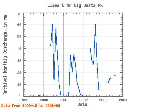
| Statistic | Jan | Feb | Mar | Apr | May | Jun | Jul | Aug | Sep | Oct | Nov | Dec | Annual |
|---|---|---|---|---|---|---|---|---|---|---|---|---|---|
| Mean | 0.00 | 0.00 | 0.00 | 3.40 | 34.05 | 29.14 | 25.82 | 41.38 | 36.60 | 5.84 | 1.12 | 0.18 | 186.07 |
| Standard Deviation | 0.00 | 0.00 | 0.00 | 5.83 | 12.86 | 23.29 | 10.90 | 22.56 | 23.49 | 3.83 | 1.09 | 0.35 | 42.69 |
| Min | 0.00 | 0.00 | 0.00 | 0.00 | 15.46 | 5.40 | 10.52 | 17.77 | 11.32 | 0.86 | 0.00 | 0.00 | 139.16 |
| Max | 0.00 | 0.00 | 0.00 | 12.13 | 43.78 | 60.60 | 36.34 | 62.48 | 67.76 | 10.18 | 2.16 | 0.71 | 222.62 |
| Coefficient of Variation | 1.71 | 0.38 | 0.80 | 0.42 | 0.55 | 0.64 | 0.66 | 0.98 | 2.00 | 0.23 |
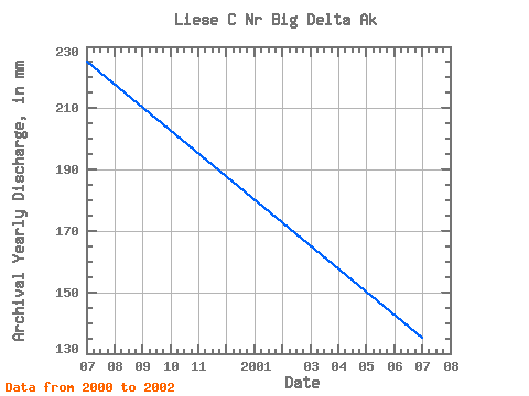
| Year | Jan | Feb | Mar | Apr | May | Jun | Jul | Aug | Sep | Oct | Nov | Dec | Annual | 1999 | 0.86 | 0.00 | 0.00 | 2000 | 0.00 | 0.00 | 0.00 | 0.00 | 43.78 | 60.60 | 10.52 | 58.77 | 37.43 | 10.18 | 2.16 | 0.00 | 222.62 | 2001 | 0.00 | 0.00 | 0.00 | 1.11 | 35.63 | 20.58 | 36.34 | 26.50 | 11.32 | 6.51 | 1.94 | 0.71 | 139.16 | 2002 | 0.00 | 0.00 | 0.00 | 0.37 | 41.34 | 29.96 | 27.74 | 62.48 | 29.90 | 5.80 | 0.37 | 0.00 | 196.45 | 2003 | 0.00 | 0.00 | 0.00 | 12.13 | 15.46 | 5.40 | 28.69 | 17.77 | 67.76 |
|---|
 Return to R-Arctic Net Home Page
