|
|
|||||||||||||||||
| Point ID: 9412 | Downloads | Plots | Site Data | Code: 15478040 |
|
|
|||||||||||||||||
| Download | |
|---|---|
| Site Descriptor Information | Site Time Series Data |
| Link to all available data | |
|
|
| View: | Statistics | Time Series |
| Units: | m3/s |
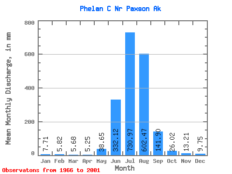
| Statistic | Jan | Feb | Mar | Apr | May | Jun | Jul | Aug | Sep | Oct | Nov | Dec | Annual |
|---|---|---|---|---|---|---|---|---|---|---|---|---|---|
| Mean | 7.71 | 5.87 | 5.67 | 5.21 | 38.65 | 332.15 | 730.84 | 602.37 | 141.89 | 26.03 | 13.17 | 9.75 | 1906.27 |
| Standard Deviation | 2.74 | 2.29 | 2.27 | 2.02 | 27.78 | 108.95 | 177.10 | 234.41 | 81.38 | 7.92 | 4.25 | 3.28 | 416.44 |
| Min | 3.56 | 2.16 | 2.37 | 2.30 | 5.75 | 169.33 | 434.50 | 176.74 | 33.26 | 13.32 | 5.82 | 4.83 | 1190.42 |
| Max | 12.80 | 9.81 | 9.58 | 9.27 | 115.57 | 574.79 | 1103.74 | 987.07 | 299.09 | 41.64 | 22.22 | 16.49 | 2590.41 |
| Coefficient of Variation | 0.35 | 0.39 | 0.40 | 0.39 | 0.72 | 0.33 | 0.24 | 0.39 | 0.57 | 0.30 | 0.32 | 0.34 | 0.22 |
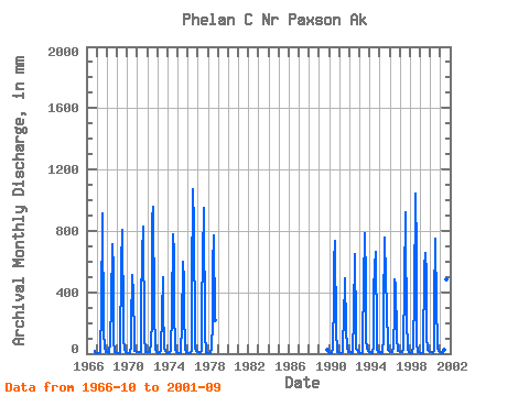
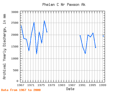
| Year | Jan | Feb | Mar | Apr | May | Jun | Jul | Aug | Sep | Oct | Nov | Dec | Annual | 1966 | 21.37 | 10.38 | 5.98 | 1967 | 3.56 | 2.16 | 2.37 | 2.30 | 11.92 | 286.31 | 940.69 | 939.70 | 150.43 | 30.64 | 19.14 | 14.64 | 2375.95 | 1968 | 11.08 | 7.61 | 6.59 | 4.67 | 85.63 | 331.85 | 734.84 | 558.91 | 79.35 | 13.71 | 8.12 | 6.36 | 1830.10 | 1969 | 4.83 | 3.60 | 2.37 | 2.30 | 43.75 | 574.79 | 829.84 | 214.51 | 100.89 | 28.87 | 9.76 | 6.59 | 1812.21 | 1970 | 5.02 | 3.71 | 4.07 | 3.94 | 57.22 | 187.83 | 529.33 | 398.67 | 94.68 | 19.66 | 14.39 | 11.64 | 1316.48 | 1971 | 10.22 | 8.73 | 9.58 | 9.27 | 13.84 | 325.34 | 668.06 | 855.55 | 116.61 | 14.61 | 12.55 | 12.46 | 2035.90 | 1972 | 12.03 | 9.81 | 9.58 | 8.12 | 73.32 | 214.07 | 902.47 | 987.07 | 279.74 | 31.27 | 12.03 | 9.58 | 2521.09 | 1973 | 7.20 | 5.48 | 6.02 | 5.82 | 16.92 | 260.91 | 514.75 | 311.19 | 34.91 | 20.59 | 11.64 | 5.75 | 1190.42 | 1974 | 4.30 | 3.08 | 3.37 | 3.94 | 21.72 | 272.61 | 807.21 | 676.58 | 295.92 | 24.93 | 9.44 | 7.20 | 2111.40 | 1975 | 5.60 | 4.40 | 4.83 | 4.67 | 32.06 | 169.33 | 620.86 | 485.30 | 279.04 | 33.13 | 7.12 | 7.05 | 1639.17 | 1976 | 4.83 | 4.40 | 4.83 | 4.83 | 21.76 | 440.55 | 1103.74 | 863.22 | 100.42 | 40.64 | 17.81 | 11.53 | 2590.41 | 1977 | 9.15 | 7.14 | 7.20 | 6.97 | 28.26 | 307.69 | 637.04 | 978.78 | 123.80 | 16.87 | 5.82 | 4.83 | 2110.47 | 1978 | 4.83 | 2.16 | 2.37 | 2.30 | 38.48 | 203.01 | 594.33 | 798.58 | 215.94 | 1989 | 26.47 | 15.96 | 10.53 | 1990 | 6.82 | 4.40 | 3.72 | 3.44 | 35.07 | 361.33 | 620.94 | 759.10 | 139.67 | 23.15 | 9.90 | 7.59 | 1956.90 | 1991 | 7.20 | 4.40 | 3.40 | 2.30 | 10.90 | 281.27 | 434.50 | 506.19 | 172.03 | 35.60 | 16.96 | 12.65 | 1476.59 | 1992 | 10.21 | 8.20 | 6.90 | 4.67 | 5.75 | 252.09 | 672.21 | 176.74 | 33.26 | 23.14 | 11.78 | 9.12 | 1202.96 | 1993 | 7.20 | 6.56 | 4.83 | 4.67 | 75.96 | 463.14 | 809.16 | 485.76 | 94.62 | 30.73 | 15.49 | 11.16 | 1992.76 | 1994 | 9.19 | 6.56 | 6.63 | 6.42 | 55.86 | 398.74 | 589.58 | 684.01 | 113.05 | 25.16 | 12.87 | 9.58 | 1901.19 | 1995 | 7.43 | 6.56 | 6.02 | 6.40 | 115.57 | 270.05 | 782.38 | 509.83 | 299.09 | 41.64 | 22.22 | 16.49 | 2066.47 | 1996 | 12.80 | 9.57 | 9.58 | 7.43 | 45.36 | 260.61 | 498.74 | 460.29 | 109.33 | 20.61 | 17.73 | 14.87 | 1454.44 | 1997 | 11.64 | 8.72 | 7.89 | 8.13 | 27.49 | 470.19 | 952.81 | 770.95 | 230.57 | 26.60 | 13.97 | 9.07 | 2516.90 | 1998 | 7.20 | 6.56 | 7.20 | 6.97 | 57.52 | 368.38 | 1078.83 | 678.52 | 74.55 | 13.32 | 7.77 | 5.32 | 2286.23 | 1999 | 4.21 | 3.38 | 3.56 | 3.78 | 10.45 | 556.93 | 676.53 | 533.05 | 112.81 | 26.14 | 14.66 | 11.40 | 1944.53 | 2000 | 9.49 | 7.55 | 7.42 | 6.59 | 16.04 | 341.28 | 773.40 | 321.49 | 69.09 | 35.91 | 18.51 | 12.69 | 1605.37 | 2001 | 9.10 | 6.20 | 5.64 | 5.20 | 26.63 | 373.34 | 767.89 | 502.79 | 85.63 |
|---|
 Return to R-Arctic Net Home Page