|
|
|||||||||||||||||
| Point ID: 9410 | Downloads | Plots | Site Data | Code: 15477770 |
|
|
|||||||||||||||||
| Download | |
|---|---|
| Site Descriptor Information | Site Time Series Data |
| Link to all available data | |
|
|
| View: | Statistics | Time Series |
| Units: | m3/s |
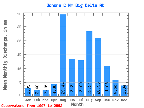
| Statistic | Jan | Feb | Mar | Apr | May | Jun | Jul | Aug | Sep | Oct | Nov | Dec | Annual |
|---|---|---|---|---|---|---|---|---|---|---|---|---|---|
| Mean | 3.03 | 2.43 | 2.42 | 4.38 | 29.44 | 13.32 | 13.04 | 23.32 | 20.97 | 11.03 | 6.03 | 3.97 | 130.57 |
| Standard Deviation | 1.25 | 1.18 | 1.30 | 1.87 | 15.46 | 6.06 | 3.92 | 12.14 | 15.60 | 8.27 | 3.33 | 1.69 | 70.71 |
| Min | 1.99 | 1.41 | 1.25 | 2.46 | 11.91 | 4.67 | 8.66 | 11.95 | 7.25 | 4.52 | 3.55 | 2.69 | 68.73 |
| Max | 4.74 | 3.77 | 4.03 | 6.97 | 50.09 | 20.65 | 19.00 | 44.61 | 49.91 | 24.76 | 11.49 | 6.60 | 229.54 |
| Coefficient of Variation | 0.41 | 0.48 | 0.54 | 0.43 | 0.53 | 0.46 | 0.30 | 0.52 | 0.74 | 0.75 | 0.55 | 0.43 | 0.54 |
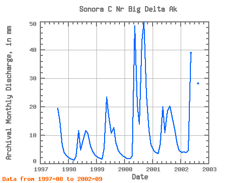
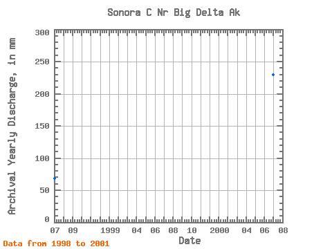
| Year | Jan | Feb | Mar | Apr | May | Jun | Jul | Aug | Sep | Oct | Nov | Dec | Annual | 1997 | 20.11 | 15.03 | 6.52 | 3.75 | 2.69 | 1998 | 1.99 | 1.41 | 1.25 | 2.46 | 11.91 | 4.67 | 8.66 | 11.95 | 10.72 | 6.63 | 4.43 | 3.02 | 68.73 | 1999 | 2.24 | 1.67 | 1.53 | 5.24 | 24.26 | 16.75 | 10.93 | 13.12 | 7.25 | 4.52 | 3.55 | 2.79 | 93.42 | 2000 | 2.19 | 1.66 | 1.67 | 2.71 | 50.09 | 20.65 | 14.38 | 44.61 | 49.91 | 24.76 | 11.49 | 6.60 | 229.54 | 2001 | 4.74 | 3.67 | 3.62 | 6.97 | 20.64 | 10.78 | 19.00 | 20.92 | 16.48 | 12.73 | 6.90 | 4.75 | 130.58 | 2002 | 4.00 | 3.77 | 4.03 | 4.54 | 40.28 | 13.73 | 12.21 | 29.18 | 26.43 |
|---|
 Return to R-Arctic Net Home Page