|
|
|||||||||||||||||
| Point ID: 9409 | Downloads | Plots | Site Data | Code: 15477768 |
|
|
|||||||||||||||||
| Download | |
|---|---|
| Site Descriptor Information | Site Time Series Data |
| Link to all available data | |
|
|
| View: | Statistics | Time Series |
| Units: | m3/s |
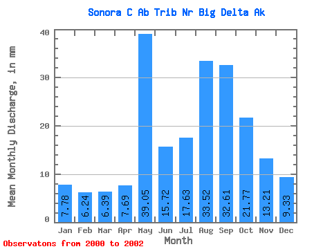
| Statistic | Jan | Feb | Mar | Apr | May | Jun | Jul | Aug | Sep | Oct | Nov | Dec | Annual |
|---|---|---|---|---|---|---|---|---|---|---|---|---|---|
| Mean | 7.70 | 6.31 | 6.39 | 7.73 | 39.08 | 15.74 | 17.57 | 33.59 | 32.60 | 21.68 | 13.17 | 9.26 | 158.85 |
| Standard Deviation | 3.15 | 1.59 | 1.19 | 2.71 | 16.23 | 2.71 | 4.92 | 8.79 | 13.88 | 11.05 | 7.44 | 5.09 | |
| Min | 5.47 | 5.18 | 5.56 | 5.81 | 21.05 | 13.45 | 12.61 | 23.44 | 17.41 | 13.87 | 7.90 | 5.66 | 158.85 |
| Max | 9.93 | 7.44 | 7.23 | 9.64 | 52.50 | 18.73 | 22.46 | 39.03 | 44.61 | 29.50 | 18.43 | 12.85 | 158.85 |
| Coefficient of Variation | 0.41 | 0.25 | 0.18 | 0.35 | 0.41 | 0.17 | 0.28 | 0.26 | 0.43 | 0.51 | 0.56 | 0.55 |
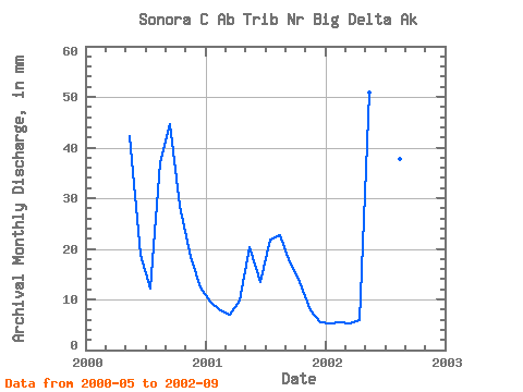
| Year | Jan | Feb | Mar | Apr | May | Jun | Jul | Aug | Sep | Oct | Nov | Dec | Annual | 2000 | 43.69 | 18.73 | 12.61 | 38.30 | 44.61 | 29.50 | 18.43 | 12.85 | 2001 | 9.93 | 7.44 | 7.23 | 9.64 | 21.05 | 13.45 | 22.46 | 23.44 | 17.41 | 13.87 | 7.90 | 5.66 | 158.85 | 2002 | 5.47 | 5.18 | 5.56 | 5.81 | 52.50 | 15.04 | 17.62 | 39.03 | 35.78 |
|---|
 Return to R-Arctic Net Home Page