|
|
|||||||||||||||||
| Point ID: 9407 | Downloads | Plots | Site Data | Code: 15297450 |
|
|
|||||||||||||||||
| Download | |
|---|---|
| Site Descriptor Information | Site Time Series Data |
| Link to all available data | |
|
|
| View: | Statistics | Time Series |
| Units: | m3/s |
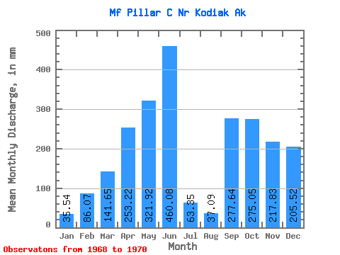
| Statistic | Jan | Feb | Mar | Apr | May | Jun | Jul | Aug | Sep | Oct | Nov | Dec | Annual |
|---|---|---|---|---|---|---|---|---|---|---|---|---|---|
| Mean | 35.44 | 87.03 | 141.62 | 253.24 | 321.72 | 460.06 | 63.34 | 36.91 | 277.43 | 275.19 | 217.82 | 205.72 | 2800.65 |
| Standard Deviation | 32.47 | 98.53 | 130.24 | 133.85 | 199.71 | 261.40 | 14.79 | 260.88 | |||||
| Min | 12.48 | 17.36 | 49.52 | 158.59 | 180.50 | 460.06 | 63.34 | 36.91 | 277.43 | 90.36 | 207.36 | 21.25 | 2800.65 |
| Max | 58.39 | 156.71 | 233.71 | 347.89 | 462.94 | 460.06 | 63.34 | 36.91 | 277.43 | 460.03 | 228.28 | 390.19 | 2800.65 |
| Coefficient of Variation | 0.92 | 1.13 | 0.92 | 0.53 | 0.62 | 0.95 | 0.07 | 1.27 |
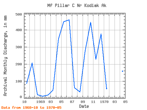
| Year | Jan | Feb | Mar | Apr | May | Jun | Jul | Aug | Sep | Oct | Nov | Dec | Annual | 1968 | 90.36 | 207.36 | 21.25 | 1969 | 12.48 | 17.36 | 49.52 | 347.89 | 462.94 | 460.06 | 63.34 | 36.91 | 277.43 | 460.03 | 228.28 | 390.19 | 2800.65 | 1970 | 58.39 | 156.71 | 233.71 | 158.59 | 180.50 |
|---|
 Return to R-Arctic Net Home Page