|
|
|||||||||||||||||
| Point ID: 9390 | Downloads | Plots | Site Data | Code: 15746990 |
|
|
|||||||||||||||||
| Download | |
|---|---|
| Site Descriptor Information | Site Time Series Data |
| Link to all available data | |
|
|
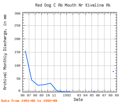
| View: | Statistics | Time Series |
| Units: | m3/s |
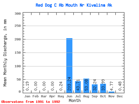
| Statistic | Jan | Feb | Mar | Apr | May | Jun | Jul | Aug | Sep | Oct | Nov | Dec | Annual |
|---|---|---|---|---|---|---|---|---|---|---|---|---|---|
| Mean | 0.15 | 0.00 | 0.00 | 0.00 | 0.19 | 176.77 | 38.01 | 46.16 | 28.02 | 29.54 | 4.14 | 0.44 | |
| Standard Deviation | 61.51 | 3.03 | 32.97 | 6.55 | |||||||||
| Min | 0.15 | 0.00 | 0.00 | 0.00 | 0.19 | 133.28 | 35.86 | 22.85 | 23.39 | 29.54 | 4.14 | 0.44 | |
| Max | 0.15 | 0.00 | 0.00 | 0.00 | 0.19 | 220.27 | 40.15 | 69.47 | 32.65 | 29.54 | 4.14 | 0.44 | |
| Coefficient of Variation | 0.35 | 0.08 | 0.71 | 0.23 |
| Year | Jan | Feb | Mar | Apr | May | Jun | Jul | Aug | Sep | Oct | Nov | Dec | Annual | 1991 | 133.28 | 40.15 | 22.85 | 23.39 | 29.54 | 4.14 | 0.44 | 1992 | 0.15 | 0.00 | 0.00 | 0.00 | 0.19 | 220.27 | 35.86 | 69.47 | 32.65 |
|---|
 Return to R-Arctic Net Home Page