|
|
|||||||||||||||||
| Point ID: 9387 | Downloads | Plots | Site Data | Code: 15746980 |
|
|
|||||||||||||||||
| Download | |
|---|---|
| Site Descriptor Information | Site Time Series Data |
| Link to all available data | |
|
|
| View: | Statistics | Time Series |
| Units: | m3/s |
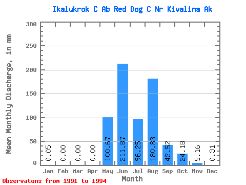
| Statistic | Jan | Feb | Mar | Apr | May | Jun | Jul | Aug | Sep | Oct | Nov | Dec | Annual |
|---|---|---|---|---|---|---|---|---|---|---|---|---|---|
| Mean | 0.06 | 0.00 | 0.00 | 0.00 | 100.67 | 211.88 | 96.24 | 180.80 | 42.53 | 24.18 | 5.16 | 0.32 | |
| Standard Deviation | 141.96 | 87.58 | 61.97 | 196.95 | 26.30 | ||||||||
| Min | 0.06 | 0.00 | 0.00 | 0.00 | 0.29 | 118.45 | 53.79 | 30.67 | 22.63 | 24.18 | 5.16 | 0.32 | |
| Max | 0.06 | 0.00 | 0.00 | 0.00 | 201.04 | 292.11 | 167.35 | 403.81 | 72.35 | 24.18 | 5.16 | 0.32 | |
| Coefficient of Variation | 1.41 | 0.41 | 0.64 | 1.09 | 0.62 |
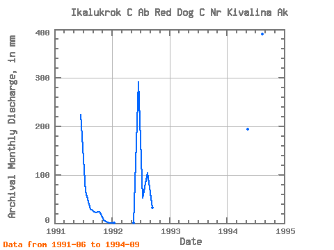
| Year | Jan | Feb | Mar | Apr | May | Jun | Jul | Aug | Sep | Oct | Nov | Dec | Annual | 1991 | 225.07 | 67.57 | 30.67 | 22.63 | 24.18 | 5.16 | 0.32 | 1992 | 0.06 | 0.00 | 0.00 | 0.00 | 0.29 | 292.11 | 53.79 | 107.93 | 32.60 | 1994 | 201.04 | 118.45 | 167.35 | 403.81 | 72.35 |
|---|
 Return to R-Arctic Net Home Page