|
|
|||||||||||||||||
| Point ID: 9381 | Downloads | Plots | Site Data | Code: 15297655 |
|
|
|||||||||||||||||
| Download | |
|---|---|
| Site Descriptor Information | Site Time Series Data |
| Link to all available data | |
|
|
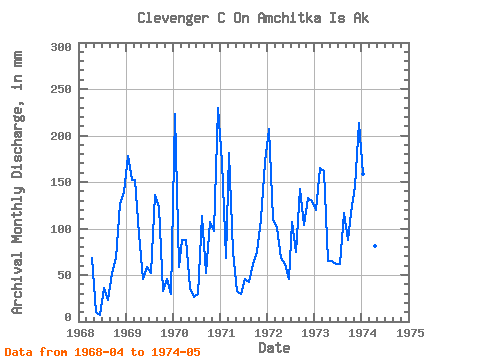
| View: | Statistics | Time Series |
| Units: | m3/s |
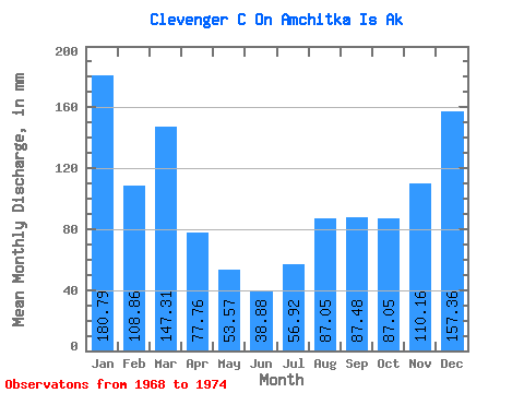
| Statistic | Jan | Feb | Mar | Apr | May | Jun | Jul | Aug | Sep | Oct | Nov | Dec | Annual |
|---|---|---|---|---|---|---|---|---|---|---|---|---|---|
| Mean | 182.33 | 111.24 | 146.64 | 76.54 | 52.17 | 37.96 | 56.91 | 87.23 | 86.63 | 86.30 | 110.03 | 156.94 | 1211.87 |
| Standard Deviation | 38.37 | 44.41 | 39.74 | 11.36 | 31.36 | 20.96 | 28.80 | 46.92 | 38.65 | 32.40 | 35.92 | 75.08 | 136.34 |
| Min | 123.64 | 54.68 | 90.60 | 64.15 | 9.83 | 6.91 | 30.13 | 25.05 | 51.41 | 34.34 | 46.22 | 29.05 | 1072.83 |
| Max | 232.27 | 156.97 | 187.46 | 92.45 | 108.43 | 60.48 | 110.47 | 141.68 | 141.80 | 119.86 | 146.66 | 237.56 | 1401.69 |
| Coefficient of Variation | 0.21 | 0.40 | 0.27 | 0.15 | 0.60 | 0.55 | 0.51 | 0.54 | 0.45 | 0.38 | 0.33 | 0.48 | 0.11 |
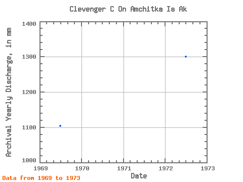
| Year | Jan | Feb | Mar | Apr | May | Jun | Jul | Aug | Sep | Oct | Nov | Dec | Annual | 1968 | 67.50 | 9.83 | 6.91 | 36.82 | 25.05 | 51.41 | 69.87 | 126.36 | 143.83 | 1969 | 182.93 | 143.79 | 158.74 | 92.45 | 48.38 | 58.54 | 53.56 | 141.68 | 123.88 | 34.34 | 46.22 | 29.05 | 1117.91 | 1970 | 232.27 | 54.68 | 90.60 | 89.10 | 35.96 | 26.03 | 30.13 | 116.73 | 52.60 | 111.22 | 96.66 | 237.56 | 1165.51 | 1971 | 175.80 | 63.61 | 187.46 | 74.63 | 33.37 | 28.94 | 46.87 | 42.01 | 61.45 | 75.70 | 109.94 | 176.34 | 1072.83 | 1972 | 214.89 | 102.86 | 103.45 | 66.53 | 63.60 | 46.87 | 110.47 | 76.78 | 141.80 | 106.80 | 134.35 | 133.04 | 1301.39 | 1973 | 123.64 | 156.97 | 168.24 | 64.15 | 65.65 | 60.48 | 63.60 | 121.16 | 88.67 | 119.86 | 146.66 | 221.80 | 1401.69 | 1974 | 164.46 | 145.53 | 171.37 | 81.43 | 108.43 |
|---|
 Return to R-Arctic Net Home Page