|
|
|||||||||||||||||
| Point ID: 9374 | Downloads | Plots | Site Data | Code: 15297773 |
|
|
|||||||||||||||||
| Download | |
|---|---|
| Site Descriptor Information | Site Time Series Data |
| Link to all available data | |
|
|
| View: | Statistics | Time Series |
| Units: | m3/s |
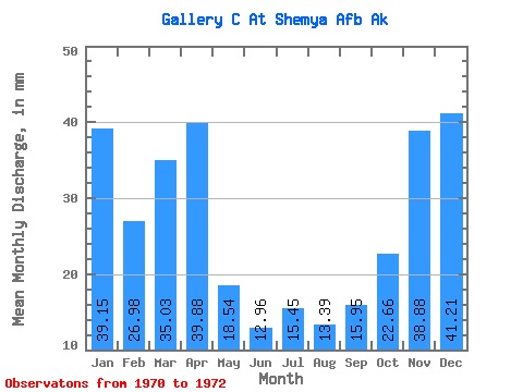
| Statistic | Jan | Feb | Mar | Apr | May | Jun | Jul | Aug | Sep | Oct | Nov | Dec | Annual |
|---|---|---|---|---|---|---|---|---|---|---|---|---|---|
| Mean | 39.59 | 26.96 | 35.29 | 39.81 | 18.26 | 13.19 | 14.94 | 13.76 | 15.60 | 22.69 | 38.73 | 41.52 | 307.58 |
| Standard Deviation | 2.47 | 7.04 | 2.30 | 24.53 | 14.26 | 8.04 | 9.47 | 6.53 | 8.77 | 12.31 | 13.72 | 3.74 | |
| Min | 37.84 | 21.99 | 33.66 | 22.46 | 8.17 | 7.51 | 8.24 | 9.14 | 9.40 | 13.99 | 26.59 | 38.87 | 307.58 |
| Max | 41.33 | 31.94 | 36.91 | 57.16 | 28.34 | 18.88 | 21.63 | 18.37 | 21.80 | 31.40 | 53.61 | 44.16 | 307.58 |
| Coefficient of Variation | 0.06 | 0.26 | 0.07 | 0.62 | 0.78 | 0.61 | 0.63 | 0.47 | 0.56 | 0.54 | 0.35 | 0.09 |
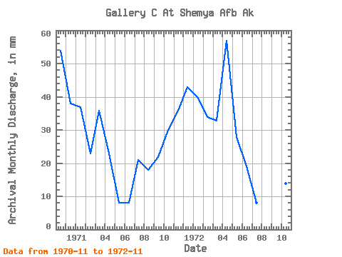
| Year | Jan | Feb | Mar | Apr | May | Jun | Jul | Aug | Sep | Oct | Nov | Dec | Annual | 1970 | 53.61 | 38.87 | 1971 | 37.84 | 21.99 | 36.91 | 22.46 | 8.17 | 7.51 | 21.63 | 18.37 | 21.80 | 31.40 | 35.99 | 44.16 | 307.58 | 1972 | 41.33 | 31.94 | 33.66 | 57.16 | 28.34 | 18.88 | 8.24 | 9.14 | 9.40 | 13.99 | 26.59 |
|---|
 Return to R-Arctic Net Home Page