|
|
|||||||||||||||||
| Point ID: 9365 | Downloads | Plots | Site Data | Code: 15297625 |
|
|
|||||||||||||||||
| Download | |
|---|---|
| Site Descriptor Information | Site Time Series Data |
| Link to all available data | |
|
|
| View: | Statistics | Time Series |
| Units: | m3/s |
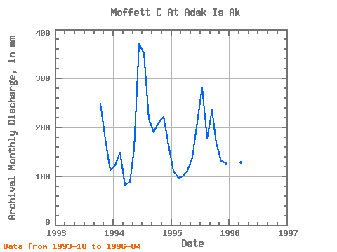
| Statistic | Jan | Feb | Mar | Apr | May | Jun | Jul | Aug | Sep | Oct | Nov | Dec | Annual |
|---|---|---|---|---|---|---|---|---|---|---|---|---|---|
| Mean | 119.37 | 116.55 | 106.82 | 100.33 | 151.76 | 291.40 | 327.08 | 203.96 | 213.40 | 215.84 | 176.00 | 138.96 | 2137.66 |
| Standard Deviation | 6.02 | 24.20 | 23.97 | 11.67 | 11.78 | 112.22 | 51.79 | 28.81 | 32.38 | 41.92 | 45.17 | 27.57 | 308.56 |
| Min | 115.19 | 91.52 | 85.09 | 88.01 | 143.43 | 212.04 | 290.46 | 183.58 | 190.51 | 173.54 | 131.32 | 116.03 | 1919.47 |
| Max | 126.27 | 139.83 | 132.53 | 111.20 | 160.09 | 370.75 | 363.70 | 224.33 | 236.30 | 257.38 | 221.66 | 169.56 | 2355.84 |
| Coefficient of Variation | 0.05 | 0.21 | 0.22 | 0.12 | 0.08 | 0.39 | 0.16 | 0.14 | 0.15 | 0.19 | 0.26 | 0.20 | 0.14 |
| Year | Jan | Feb | Mar | Apr | May | Jun | Jul | Aug | Sep | Oct | Nov | Dec | Annual | 1993 | 257.38 | 175.03 | 116.03 | 1994 | 126.27 | 139.83 | 85.09 | 88.01 | 160.09 | 370.75 | 363.70 | 224.33 | 190.51 | 216.61 | 221.66 | 169.56 | 2355.84 | 1995 | 115.19 | 91.52 | 102.83 | 111.20 | 143.43 | 212.04 | 290.46 | 183.58 | 236.30 | 173.54 | 131.32 | 131.29 | 1919.47 | 1996 | 116.66 | 118.30 | 132.53 | 101.79 |
|---|
 Return to R-Arctic Net Home Page
