|
|
|||||||||||||||||
| Point ID: 9364 | Downloads | Plots | Site Data | Code: 15297617 |
|
|
|||||||||||||||||
| Download | |
|---|---|
| Site Descriptor Information | Site Time Series Data |
| Link to all available data | |
|
|
| View: | Statistics | Time Series |
| Units: | m3/s |
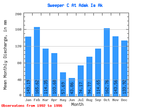
| Statistic | Jan | Feb | Mar | Apr | May | Jun | Jul | Aug | Sep | Oct | Nov | Dec | Annual |
|---|---|---|---|---|---|---|---|---|---|---|---|---|---|
| Mean | 143.49 | 166.84 | 114.34 | 103.83 | 57.20 | 43.90 | 74.50 | 94.72 | 114.72 | 163.17 | 143.64 | 134.15 | 1407.95 |
| Standard Deviation | 53.16 | 36.22 | 14.95 | 16.32 | 2.33 | 6.36 | 6.04 | 49.87 | 39.87 | 43.06 | 31.90 | 13.39 | 138.84 |
| Min | 95.36 | 141.07 | 99.61 | 84.51 | 54.59 | 36.59 | 70.04 | 50.54 | 83.21 | 138.05 | 115.88 | 117.79 | 1265.61 |
| Max | 200.12 | 219.94 | 129.12 | 122.69 | 59.04 | 48.19 | 81.37 | 148.79 | 159.54 | 227.40 | 185.49 | 146.79 | 1543.01 |
| Coefficient of Variation | 0.37 | 0.22 | 0.13 | 0.16 | 0.04 | 0.14 | 0.08 | 0.53 | 0.35 | 0.26 | 0.22 | 0.10 | 0.10 |
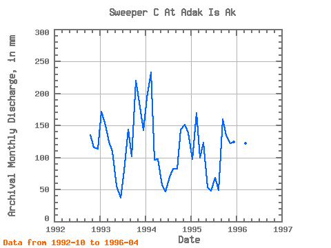
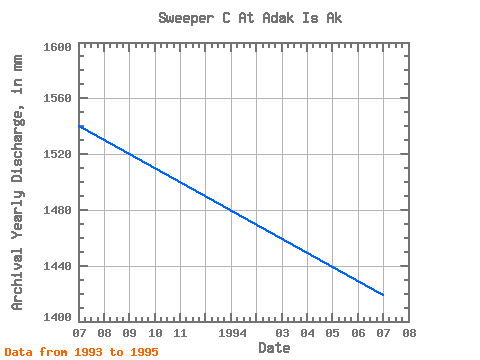
| Year | Jan | Feb | Mar | Apr | May | Jun | Jul | Aug | Sep | Oct | Nov | Dec | Annual | 1992 | 139.08 | 115.88 | 117.79 | 1993 | 177.46 | 141.07 | 129.12 | 109.96 | 57.98 | 36.59 | 81.37 | 148.79 | 101.42 | 227.40 | 185.49 | 146.79 | 1543.01 | 1994 | 200.12 | 219.94 | 99.61 | 98.16 | 59.04 | 46.92 | 72.10 | 84.83 | 83.21 | 148.15 | 151.27 | 143.20 | 1415.23 | 1995 | 101.04 | 159.44 | 103.47 | 122.69 | 54.59 | 48.19 | 70.04 | 50.54 | 159.54 | 138.05 | 121.92 | 128.82 | 1265.61 | 1996 | 95.36 | 146.92 | 125.16 | 84.51 |
|---|
 Return to R-Arctic Net Home Page