|
|
|||||||||||||||||
| Point ID: 9356 | Downloads | Plots | Site Data | Code: 15476400 |
|
|
|||||||||||||||||
| Download | |
|---|---|
| Site Descriptor Information | Site Time Series Data |
| Link to all available data | |
|
|
| View: | Statistics | Time Series |
| Units: | m3/s |
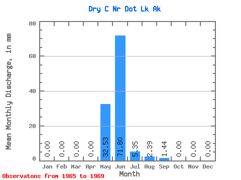
| Statistic | Jan | Feb | Mar | Apr | May | Jun | Jul | Aug | Sep | Oct | Nov | Dec | Annual |
|---|---|---|---|---|---|---|---|---|---|---|---|---|---|
| Mean | 0.00 | 0.00 | 0.00 | 0.00 | 32.52 | 71.80 | 5.34 | 2.38 | 1.45 | 0.00 | 0.00 | 0.00 | 136.86 |
| Standard Deviation | 0.00 | 0.00 | 0.00 | 0.00 | 20.22 | 49.63 | 8.28 | 4.69 | 2.46 | 0.00 | 0.00 | 0.00 | 32.24 |
| Min | 0.00 | 0.00 | 0.00 | 0.00 | 13.56 | 0.10 | 0.00 | 0.00 | 0.00 | 0.00 | 0.00 | 0.00 | 113.81 |
| Max | 0.00 | 0.00 | 0.00 | 0.00 | 61.16 | 108.16 | 17.55 | 9.42 | 5.12 | 0.00 | 0.00 | 0.00 | 173.70 |
| Coefficient of Variation | 0.62 | 0.69 | 1.55 | 1.97 | 1.70 | 0.24 |
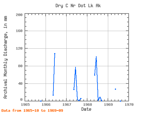
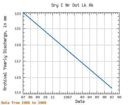
| Year | Jan | Feb | Mar | Apr | May | Jun | Jul | Aug | Sep | Oct | Nov | Dec | Annual | 1965 | 0.00 | 0.00 | 0.00 | 1966 | 0.00 | 0.00 | 0.00 | 0.00 | 13.56 | 108.16 | 0.00 | 0.00 | 0.00 | 0.00 | 0.00 | 0.00 | 123.06 | 1967 | 0.00 | 0.00 | 0.00 | 0.00 | 27.40 | 77.16 | 3.37 | 0.12 | 5.12 | 0.00 | 0.00 | 0.00 | 113.81 | 1968 | 0.00 | 0.00 | 0.00 | 0.00 | 61.16 | 101.77 | 0.45 | 9.42 | 0.69 | 0.00 | 0.00 | 0.00 | 173.70 | 1969 | 0.00 | 0.00 | 0.00 | 0.00 | 27.98 | 0.10 | 17.55 | 0.00 | 0.00 |
|---|
 Return to R-Arctic Net Home Page