|
|
|||||||||||||||||
| Point ID: 9346 | Downloads | Plots | Site Data | Code: 15301500 |
|
|
|||||||||||||||||
| Download | |
|---|---|
| Site Descriptor Information | Site Time Series Data |
| Link to all available data | |
|
|
| View: | Statistics | Time Series |
| Units: | m3/s |
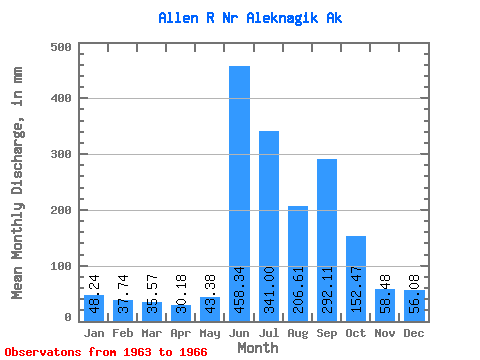
| Statistic | Jan | Feb | Mar | Apr | May | Jun | Jul | Aug | Sep | Oct | Nov | Dec | Annual |
|---|---|---|---|---|---|---|---|---|---|---|---|---|---|
| Mean | 48.23 | 38.07 | 35.56 | 30.18 | 43.37 | 458.34 | 340.95 | 206.58 | 292.11 | 152.44 | 58.48 | 56.08 | 1908.77 |
| Standard Deviation | 4.27 | 3.03 | 4.02 | 5.47 | 8.95 | 51.42 | 28.31 | 30.64 | 124.44 | 31.43 | 7.80 | 6.04 | 243.48 |
| Min | 43.38 | 34.58 | 32.53 | 26.76 | 36.75 | 409.33 | 315.39 | 161.82 | 214.04 | 116.15 | 50.15 | 49.88 | 1736.60 |
| Max | 51.42 | 40.10 | 40.12 | 36.48 | 53.55 | 511.11 | 376.99 | 231.22 | 477.94 | 170.86 | 65.60 | 61.95 | 2080.94 |
| Coefficient of Variation | 0.09 | 0.08 | 0.11 | 0.18 | 0.21 | 0.11 | 0.08 | 0.15 | 0.43 | 0.21 | 0.13 | 0.11 | 0.13 |
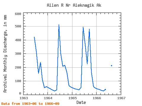
| Year | Jan | Feb | Mar | Apr | May | Jun | Jul | Aug | Sep | Oct | Nov | Dec | Annual | 1963 | 419.44 | 321.61 | 161.82 | 235.04 | 116.15 | 50.15 | 61.95 | 1964 | 51.42 | 40.10 | 34.04 | 26.76 | 36.75 | 511.11 | 315.39 | 215.34 | 214.04 | 170.32 | 65.60 | 56.39 | 1736.60 | 1965 | 49.88 | 39.52 | 40.12 | 36.48 | 53.55 | 493.48 | 376.99 | 231.22 | 477.94 | 170.86 | 59.70 | 49.88 | 2080.94 | 1966 | 43.38 | 34.58 | 32.53 | 27.29 | 39.81 | 409.33 | 349.81 | 217.93 | 241.41 |
|---|
 Return to R-Arctic Net Home Page