|
|
|||||||||||||||||
| Point ID: 9334 | Downloads | Plots | Site Data | Code: 15304200 |
|
|
|||||||||||||||||
| Download | |
|---|---|
| Site Descriptor Information | Site Time Series Data |
| Link to all available data | |

|

|
| View: | Statistics | Time Series |
| Units: | m3/s |
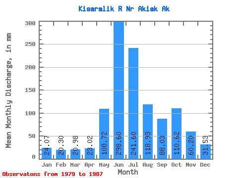
| Statistic | Jan | Feb | Mar | Apr | May | Jun | Jul | Aug | Sep | Oct | Nov | Dec | Annual |
|---|---|---|---|---|---|---|---|---|---|---|---|---|---|
| Mean | 24.06 | 20.48 | 20.97 | 23.02 | 108.71 | 298.60 | 241.56 | 118.91 | 88.03 | 110.60 | 60.20 | 31.52 | 1080.21 |
| Standard Deviation | 6.81 | 4.79 | 4.17 | 7.99 | 54.31 | 67.47 | 67.96 | 38.72 | 28.87 | 78.41 | 66.16 | 20.79 | 263.76 |
| Min | 14.08 | 12.59 | 13.35 | 13.39 | 48.76 | 165.52 | 149.66 | 61.47 | 46.56 | 51.14 | 17.45 | 14.36 | 665.32 |
| Max | 33.33 | 27.58 | 25.77 | 35.47 | 211.94 | 367.08 | 354.19 | 166.56 | 131.17 | 288.00 | 216.03 | 78.81 | 1481.65 |
| Coefficient of Variation | 0.28 | 0.23 | 0.20 | 0.35 | 0.50 | 0.23 | 0.28 | 0.33 | 0.33 | 0.71 | 1.10 | 0.66 | 0.24 |
| Year | Jan | Feb | Mar | Apr | May | Jun | Jul | Aug | Sep | Oct | Nov | Dec | Annual | 1979 | 288.00 | 216.03 | 78.81 | 1980 | 33.33 | 24.47 | 24.45 | 35.47 | 117.94 | 367.08 | 354.19 | 158.84 | 99.47 | 146.97 | 82.87 | 41.81 | 1481.65 | 1981 | 32.77 | 27.58 | 25.77 | 34.44 | 211.94 | 306.83 | 218.82 | 119.56 | 68.20 | 51.14 | 29.53 | 18.89 | 1141.88 | 1982 | 18.23 | 16.61 | 18.23 | 17.64 | 70.74 | 328.32 | 264.76 | 95.36 | 131.17 | 64.70 | 22.21 | 19.34 | 1066.05 | 1983 | 18.96 | 17.11 | 17.68 | 17.43 | 123.22 | 280.73 | 166.75 | 79.10 | 46.56 | 75.22 | 32.41 | 26.62 | 899.58 | 1984 | 25.41 | 22.15 | 22.99 | 20.93 | 48.76 | 165.52 | 149.66 | 61.47 | 60.47 | 57.37 | 17.45 | 14.36 | 665.32 | 1985 | 14.08 | 12.59 | 13.35 | 13.39 | 62.77 | 246.05 | 228.72 | 153.37 | 103.81 | 113.40 | 34.08 | 26.52 | 1017.94 | 1986 | 25.41 | 22.15 | 23.21 | 23.80 | 82.44 | 366.11 | 307.75 | 166.56 | 113.88 | 88.00 | 47.03 | 25.84 | 1289.09 | 1987 | 24.31 | 21.14 | 22.10 | 21.03 | 151.84 | 328.18 | 241.88 | 116.99 | 80.72 |
|---|
 Return to R-Arctic Net Home Page