|
|
|||||||||||||||||
| Point ID: 9326 | Downloads | Plots | Site Data | Code: 15062000 |
|
|
|||||||||||||||||
| Download | |
|---|---|
| Site Descriptor Information | Site Time Series Data |
| Link to all available data | |

|
|
| View: | Statistics | Time Series |
| Units: | m3/s |
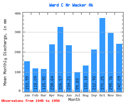
| Statistic | Jan | Feb | Mar | Apr | May | Jun | Jul | Aug | Sep | Oct | Nov | Dec | Annual |
|---|---|---|---|---|---|---|---|---|---|---|---|---|---|
| Mean | 153.97 | 119.09 | 115.94 | 238.63 | 326.49 | 234.21 | 99.80 | 133.19 | 212.94 | 370.17 | 295.74 | 242.06 | 2571.90 |
| Standard Deviation | 115.89 | 107.38 | 80.81 | 207.19 | 151.89 | 143.44 | 84.25 | 94.44 | 161.55 | 194.19 | 122.75 | 147.39 | 1136.29 |
| Min | 10.51 | 12.37 | 14.20 | 25.15 | 64.45 | 13.05 | 0.52 | 6.30 | 20.07 | 55.23 | 93.11 | 21.44 | 695.15 |
| Max | 378.53 | 355.80 | 250.71 | 648.51 | 482.43 | 433.11 | 259.98 | 307.87 | 472.60 | 751.65 | 504.14 | 457.10 | 4252.31 |
| Coefficient of Variation | 0.75 | 0.90 | 0.70 | 0.87 | 0.47 | 0.61 | 0.84 | 0.71 | 0.76 | 0.53 | 0.41 | 0.61 | 0.44 |
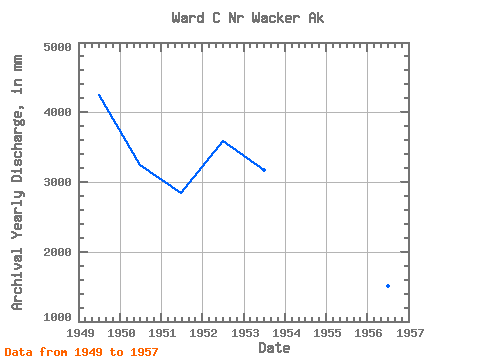
| Year | Jan | Feb | Mar | Apr | May | Jun | Jul | Aug | Sep | Oct | Nov | Dec | Annual | 1948 | 576.71 | 382.62 | 131.75 | 1949 | 191.66 | 129.43 | 226.22 | 648.51 | 454.27 | 410.79 | 191.44 | 247.11 | 391.89 | 751.65 | 504.14 | 105.30 | 4252.31 | 1950 | 10.51 | 12.37 | 112.27 | 281.59 | 459.93 | 341.51 | 259.98 | 307.87 | 472.60 | 330.07 | 220.47 | 457.10 | 3251.77 | 1951 | 185.18 | 90.55 | 144.29 | 306.87 | 482.43 | 433.11 | 89.86 | 88.15 | 158.75 | 346.38 | 254.09 | 276.28 | 2851.01 | 1952 | 266.19 | 236.14 | 146.37 | 492.96 | 441.53 | 346.30 | 158.17 | 163.28 | 336.46 | 434.25 | 280.04 | 278.11 | 3585.69 | 1953 | 127.64 | 355.80 | 250.71 | 274.65 | 460.80 | 154.00 | 129.84 | 72.57 | 254.29 | 284.79 | 400.61 | 401.50 | 3179.80 | 1954 | 178.65 | 135.20 | 123.26 | 36.73 | 240.38 | 211.30 | 54.15 | 6.30 | 20.07 | 287.75 | 379.79 | 388.18 | 2058.85 | 1955 | 151.33 | 111.86 | 44.77 | 145.02 | 188.58 | 189.93 | 25.45 | 186.47 | 173.96 | 431.63 | 93.11 | 21.44 | 1762.28 | 1956 | 12.24 | 17.84 | 15.64 | 37.16 | 293.45 | 179.77 | 14.39 | 135.78 | 67.54 | 203.25 | 279.50 | 260.80 | 1510.22 | 1957 | 37.82 | 20.33 | 14.20 | 25.15 | 64.45 | 62.30 | 74.22 | 38.34 | 40.94 | 55.23 | 163.05 | 100.18 | 695.15 | 1958 | 378.53 | 81.40 | 81.64 | 137.70 | 179.11 | 13.05 | 0.52 | 86.07 |
|---|
 Return to R-Arctic Net Home Page