|
|
|||||||||||||||||
| Point ID: 9319 | Downloads | Plots | Site Data | Code: 15056500 |
|
|
|||||||||||||||||
| Download | |
|---|---|
| Site Descriptor Information | Site Time Series Data |
| Link to all available data | |
|
|
| View: | Statistics | Time Series |
| Units: | m3/s |
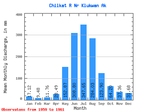
| Statistic | Jan | Feb | Mar | Apr | May | Jun | Jul | Aug | Sep | Oct | Nov | Dec | Annual |
|---|---|---|---|---|---|---|---|---|---|---|---|---|---|
| Mean | 17.12 | 9.56 | 11.76 | 28.49 | 152.85 | 308.80 | 347.60 | 283.99 | 123.90 | 64.19 | 37.36 | 31.68 | 1439.89 |
| Standard Deviation | 0.24 | 0.87 | 1.56 | 6.13 | 38.38 | 7.51 | 36.21 | 70.14 | 24.97 | 8.65 | 4.26 | 2.19 | |
| Min | 16.95 | 8.95 | 10.66 | 24.16 | 125.72 | 303.49 | 311.46 | 220.16 | 95.62 | 58.07 | 34.34 | 30.13 | 1439.89 |
| Max | 17.29 | 10.18 | 12.86 | 32.82 | 179.99 | 314.11 | 383.88 | 359.09 | 142.90 | 70.30 | 40.37 | 33.23 | 1439.89 |
| Coefficient of Variation | 0.01 | 0.09 | 0.13 | 0.21 | 0.25 | 0.02 | 0.10 | 0.25 | 0.20 | 0.14 | 0.11 | 0.07 |
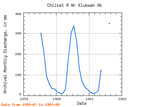
| Year | Jan | Feb | Mar | Apr | May | Jun | Jul | Aug | Sep | Oct | Nov | Dec | Annual | 1959 | 311.46 | 220.16 | 95.62 | 58.07 | 34.34 | 33.23 | 1960 | 16.95 | 10.18 | 10.66 | 32.82 | 179.99 | 303.49 | 347.47 | 272.72 | 133.18 | 70.30 | 40.37 | 30.13 | 1439.89 | 1961 | 17.29 | 8.95 | 12.86 | 24.16 | 125.72 | 314.11 | 383.88 | 359.09 | 142.90 |
|---|
 Return to R-Arctic Net Home Page