|
|
|||||||||||||||||
| Point ID: 9308 | Downloads | Plots | Site Data | Code: 15081614 |
|
|
|||||||||||||||||
| Download | |
|---|---|
| Site Descriptor Information | Site Time Series Data |
| Link to all available data | |
|

|
| View: | Statistics | Time Series |
| Units: | m3/s |
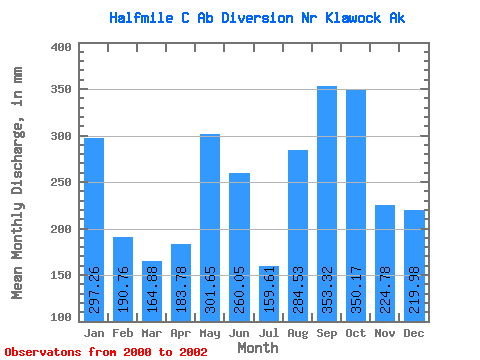
| Statistic | Jan | Feb | Mar | Apr | May | Jun | Jul | Aug | Sep | Oct | Nov | Dec | Annual |
|---|---|---|---|---|---|---|---|---|---|---|---|---|---|
| Mean | 297.23 | 192.41 | 164.90 | 183.82 | 301.55 | 259.96 | 159.58 | 284.38 | 353.26 | 350.21 | 224.69 | 219.90 | 3404.07 |
| Standard Deviation | 101.72 | 52.66 | 116.18 | 50.58 | 100.39 | 221.98 | 58.98 | 135.88 | 29.42 | 100.68 | |||
| Min | 225.30 | 155.18 | 82.75 | 148.05 | 230.56 | 103.00 | 117.88 | 188.29 | 332.45 | 350.21 | 224.69 | 148.71 | 3404.07 |
| Max | 369.16 | 229.65 | 247.05 | 219.58 | 372.53 | 416.93 | 201.29 | 380.46 | 374.06 | 350.21 | 224.69 | 291.09 | 3404.07 |
| Coefficient of Variation | 0.34 | 0.27 | 0.70 | 0.28 | 0.33 | 0.85 | 0.37 | 0.48 | 0.08 | 0.46 |
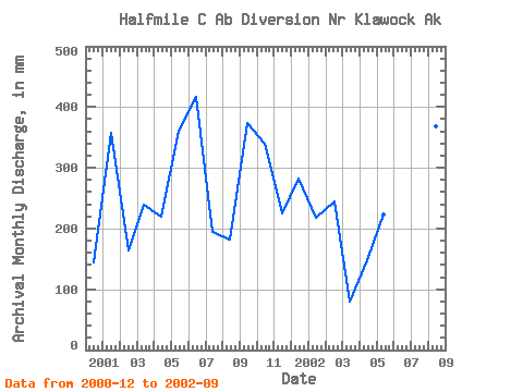
| Year | Jan | Feb | Mar | Apr | May | Jun | Jul | Aug | Sep | Oct | Nov | Dec | Annual | 2000 | 148.71 | 2001 | 369.16 | 155.18 | 247.05 | 219.58 | 372.53 | 416.93 | 201.29 | 188.29 | 374.06 | 350.21 | 224.69 | 291.09 | 3404.07 | 2002 | 225.30 | 229.65 | 82.75 | 148.05 | 230.56 | 103.00 | 117.88 | 380.46 | 332.45 |
|---|
 Return to R-Arctic Net Home Page