|
|
|||||||||||||||||
| Point ID: 9305 | Downloads | Plots | Site Data | Code: 15085700 |
|
|
|||||||||||||||||
| Download | |
|---|---|
| Site Descriptor Information | Site Time Series Data |
| Link to all available data | |
|
|
| View: | Statistics | Time Series |
| Units: | m3/s |
| Statistic | Jan | Feb | Mar | Apr | May | Jun | Jul | Aug | Sep | Oct | Nov | Dec | Annual |
|---|---|---|---|---|---|---|---|---|---|---|---|---|---|
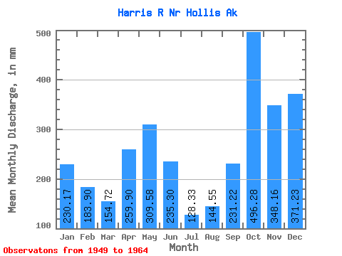
| Mean | 230.14 | 185.49 | 154.69 | 259.88 | 309.54 | 235.32 | 128.30 | 144.54 | 231.21 | 496.20 | 348.15 | 371.18 | 3042.30 |
| Standard Deviation | 176.15 | 111.73 | 86.58 | 66.49 | 109.90 | 91.33 | 47.91 | 67.56 | 88.47 | 204.07 | 105.04 | 158.22 | 442.11 |
| Min | 16.33 | 23.25 | 39.79 | 141.36 | 119.38 | 48.96 | 37.20 | 38.22 | 108.17 | 170.67 | 181.73 | 48.03 | 2072.84 |
| Max | 579.91 | 416.28 | 372.17 | 392.54 | 552.91 | 411.93 | 201.34 | 254.96 | 379.40 | 923.04 | 522.04 | 621.73 | 3720.97 |
| Coefficient of Variation | 0.77 | 0.60 | 0.56 | 0.26 | 0.35 | 0.39 | 0.37 | 0.47 | 0.38 | 0.41 | 0.30 | 0.43 | 0.14 |
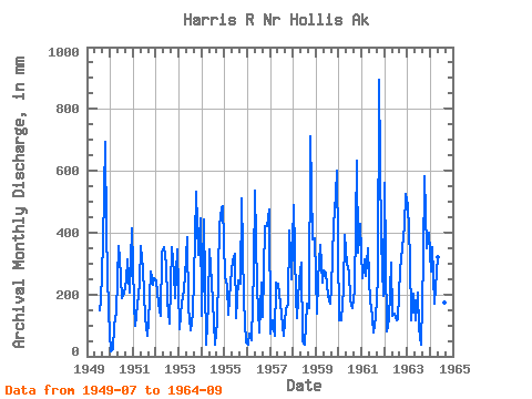
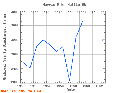
| Year | Jan | Feb | Mar | Apr | May | Jun | Jul | Aug | Sep | Oct | Nov | Dec | Annual | 1949 | 152.68 | 186.68 | 362.21 | 717.56 | 399.45 | 145.72 | 1950 | 16.33 | 23.25 | 100.02 | 141.36 | 370.26 | 316.77 | 194.20 | 214.63 | 244.69 | 324.79 | 204.45 | 427.94 | 2564.27 | 1951 | 180.59 | 93.33 | 173.51 | 236.25 | 368.54 | 283.05 | 131.99 | 69.47 | 108.17 | 283.67 | 231.46 | 262.36 | 2415.90 | 1952 | 254.33 | 161.52 | 134.13 | 335.34 | 363.01 | 298.49 | 188.65 | 108.55 | 353.98 | 275.58 | 187.69 | 357.22 | 3018.17 | 1953 | 91.87 | 167.38 | 193.91 | 256.83 | 398.47 | 156.74 | 87.51 | 140.88 | 379.40 | 549.13 | 327.97 | 460.63 | 3205.74 | 1954 | 134.82 | 416.28 | 39.79 | 165.40 | 357.05 | 238.24 | 116.53 | 38.22 | 113.41 | 440.25 | 478.81 | 502.08 | 3058.69 | 1955 | 263.45 | 218.13 | 137.19 | 236.85 | 319.59 | 330.31 | 127.45 | 254.96 | 235.60 | 527.34 | 181.73 | 48.03 | 2881.98 | 1956 | 39.77 | 70.16 | 55.12 | 283.32 | 552.91 | 220.06 | 80.56 | 246.27 | 127.76 | 436.60 | 422.77 | 488.85 | 3011.00 | 1957 | 76.51 | 108.97 | 68.81 | 238.76 | 242.38 | 169.45 | 100.89 | 67.26 | 156.34 | 170.67 | 408.57 | 259.14 | 2072.84 | 1958 | 504.16 | 179.51 | 127.81 | 244.30 | 311.26 | 48.96 | 37.20 | 175.75 | 156.11 | 733.43 | 379.04 | 394.69 | 3277.39 | 1959 | 141.04 | 231.55 | 372.17 | 239.49 | 287.72 | 270.90 | 201.34 | 177.29 | 219.20 | 440.32 | 522.04 | 621.73 | 3720.97 | 1960 | 119.38 | 110.66 | 225.66 | 392.54 | 310.27 | 275.55 | 187.78 | 159.61 | 215.55 | 653.00 | 334.98 | 442.42 | 3416.30 | 1961 | 261.51 | 294.76 | 270.14 | 348.38 | 175.94 | 167.08 | 80.23 | 132.71 | 251.90 | 923.04 | 373.87 | 201.56 | 3484.14 | 1962 | 579.91 | 76.79 | 124.28 | 301.92 | 135.97 | 136.56 | 120.71 | 122.90 | 278.74 | 365.68 | 421.62 | 543.14 | 3195.17 | 1963 | 503.80 | 299.14 | 121.85 | 204.19 | 119.38 | 205.70 | 96.06 | 39.58 | 312.92 | 601.90 | 347.85 | 412.17 | 3269.58 | 1964 | 284.62 | 330.86 | 175.97 | 273.31 | 330.39 | 411.93 | 149.00 | 177.82 | 183.38 |
|---|
 Return to R-Arctic Net Home Page