|
|
|||||||||||||||||
| Point ID: 9303 | Downloads | Plots | Site Data | Code: 15085400 |
|
|
|||||||||||||||||
| Download | |
|---|---|
| Site Descriptor Information | Site Time Series Data |
| Link to all available data | |
|
|
| View: | Statistics | Time Series |
| Units: | m3/s |
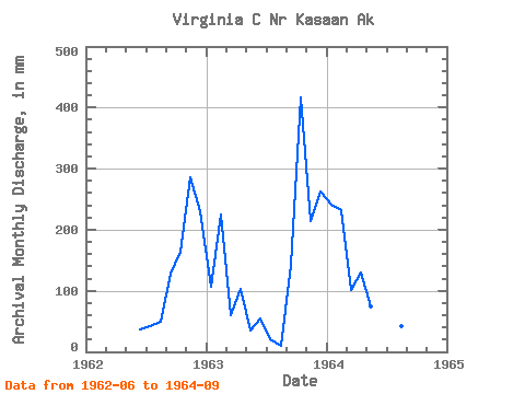
| Statistic | Jan | Feb | Mar | Apr | May | Jun | Jul | Aug | Sep | Oct | Nov | Dec | Annual |
|---|---|---|---|---|---|---|---|---|---|---|---|---|---|
| Mean | 179.51 | 215.23 | 83.37 | 116.91 | 56.50 | 42.07 | 35.37 | 35.37 | 122.73 | 299.47 | 249.98 | 254.73 | 1675.56 |
| Standard Deviation | 97.24 | 5.40 | 29.34 | 19.25 | 28.89 | 10.46 | 12.39 | 21.68 | 23.31 | 184.53 | 49.59 | 23.23 | |
| Min | 110.75 | 211.41 | 62.62 | 103.29 | 36.08 | 35.75 | 21.09 | 10.68 | 96.94 | 168.98 | 214.91 | 238.31 | 1675.56 |
| Max | 248.27 | 219.04 | 104.12 | 130.52 | 76.93 | 54.14 | 43.18 | 51.28 | 142.29 | 429.95 | 285.05 | 271.16 | 1675.56 |
| Coefficient of Variation | 0.54 | 0.03 | 0.35 | 0.17 | 0.51 | 0.25 | 0.35 | 0.61 | 0.19 | 0.62 | 0.20 | 0.09 |
| Year | Jan | Feb | Mar | Apr | May | Jun | Jul | Aug | Sep | Oct | Nov | Dec | Annual | 1962 | 36.32 | 43.18 | 51.28 | 128.96 | 168.98 | 285.05 | 238.31 | 1963 | 110.75 | 211.41 | 62.62 | 103.29 | 36.08 | 54.14 | 21.09 | 10.68 | 142.29 | 429.95 | 214.91 | 271.16 | 1675.56 | 1964 | 248.27 | 219.04 | 104.12 | 130.52 | 76.93 | 35.75 | 41.84 | 44.16 | 96.94 |
|---|
 Return to R-Arctic Net Home Page
