|
|
|||||||||||||||||
| Point ID: 9298 | Downloads | Plots | Site Data | Code: 15081995 |
|
|
|||||||||||||||||
| Download | |
|---|---|
| Site Descriptor Information | Site Time Series Data |
| Link to all available data | |
|

|
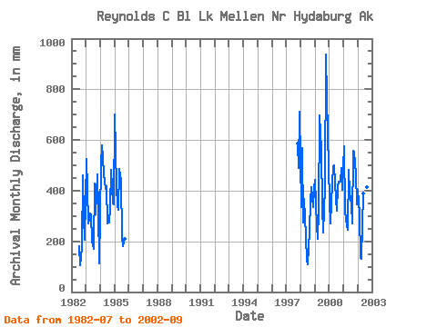
| View: | Statistics | Time Series |
| Units: | m3/s |
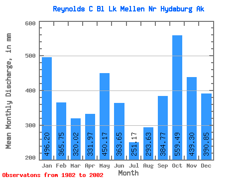
| Statistic | Jan | Feb | Mar | Apr | May | Jun | Jul | Aug | Sep | Oct | Nov | Dec | Annual |
|---|---|---|---|---|---|---|---|---|---|---|---|---|---|
| Mean | 496.19 | 368.81 | 320.02 | 331.97 | 450.09 | 363.57 | 251.22 | 293.57 | 384.75 | 559.35 | 439.25 | 390.82 | 4729.16 |
| Standard Deviation | 125.57 | 118.69 | 128.66 | 116.18 | 148.73 | 137.76 | 83.66 | 117.54 | 157.77 | 175.70 | 155.51 | 186.24 | 748.97 |
| Min | 344.66 | 244.01 | 140.06 | 129.76 | 227.04 | 124.70 | 113.47 | 108.19 | 175.25 | 426.90 | 295.05 | 116.51 | 3810.16 |
| Max | 723.51 | 546.03 | 550.11 | 494.21 | 721.55 | 562.37 | 356.87 | 441.95 | 671.46 | 968.35 | 770.03 | 735.12 | 5748.88 |
| Coefficient of Variation | 0.25 | 0.32 | 0.40 | 0.35 | 0.33 | 0.38 | 0.33 | 0.40 | 0.41 | 0.31 | 0.35 | 0.48 | 0.16 |
| Year | Jan | Feb | Mar | Apr | May | Jun | Jul | Aug | Sep | Oct | Nov | Dec | Annual | 1982 | 187.66 | 108.19 | 175.25 | 474.04 | 295.05 | 213.46 | 1983 | 541.80 | 383.66 | 280.86 | 310.27 | 311.31 | 203.69 | 176.75 | 441.95 | 305.39 | 480.52 | 320.79 | 116.51 | 3877.91 | 1984 | 521.87 | 546.03 | 550.11 | 464.85 | 422.21 | 415.93 | 279.11 | 282.67 | 333.46 | 499.75 | 348.15 | 356.99 | 5034.29 | 1985 | 723.51 | 394.27 | 349.73 | 325.66 | 501.93 | 437.31 | 229.32 | 185.73 | 210.41 | 1997 | 606.12 | 488.95 | 735.12 | 1998 | 344.66 | 533.92 | 284.67 | 368.81 | 227.04 | 124.70 | 113.47 | 244.98 | 360.63 | 426.90 | 334.54 | 423.81 | 3810.16 | 1999 | 456.98 | 244.01 | 214.89 | 316.97 | 721.55 | 562.37 | 344.77 | 241.01 | 413.92 | 968.35 | 770.03 | 506.64 | 5748.88 | 2000 | 372.36 | 253.60 | 443.56 | 494.21 | 514.98 | 367.15 | 329.89 | 432.52 | 434.93 | 450.10 | 489.50 | 417.65 | 4993.40 | 2001 | 593.61 | 303.07 | 296.25 | 245.21 | 498.12 | 394.17 | 356.87 | 278.31 | 557.27 | 568.97 | 467.02 | 356.41 | 4910.34 | 2002 | 414.76 | 291.92 | 140.06 | 129.76 | 403.55 | 403.23 | 243.20 | 426.73 | 671.46 |
|---|
 Return to R-Arctic Net Home Page