|
|
|||||||||||||||||
| Point ID: 9295 | Downloads | Plots | Site Data | Code: 15054200 |
|
|
|||||||||||||||||
| Download | |
|---|---|
| Site Descriptor Information | Site Time Series Data |
| Link to all available data | |
|

|
| View: | Statistics | Time Series |
| Units: | m3/s |
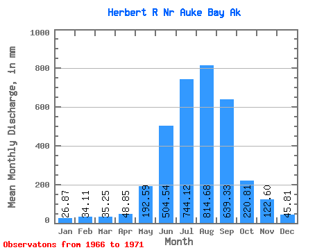
| Statistic | Jan | Feb | Mar | Apr | May | Jun | Jul | Aug | Sep | Oct | Nov | Dec | Annual |
|---|---|---|---|---|---|---|---|---|---|---|---|---|---|
| Mean | 26.87 | 34.40 | 35.24 | 48.86 | 192.57 | 504.54 | 744.00 | 814.55 | 639.33 | 220.78 | 122.61 | 45.80 | 3436.99 |
| Standard Deviation | 15.22 | 23.34 | 31.12 | 8.13 | 39.24 | 123.55 | 88.84 | 179.89 | 159.36 | 64.47 | 56.52 | 44.31 | 232.51 |
| Min | 9.81 | 8.02 | 9.82 | 37.61 | 146.19 | 400.93 | 645.83 | 612.95 | 451.77 | 159.55 | 68.48 | 19.50 | 3197.40 |
| Max | 51.03 | 63.53 | 77.93 | 56.72 | 235.49 | 676.05 | 851.20 | 998.73 | 884.32 | 320.66 | 205.92 | 124.39 | 3742.17 |
| Coefficient of Variation | 0.57 | 0.68 | 0.88 | 0.17 | 0.20 | 0.24 | 0.12 | 0.22 | 0.25 | 0.29 | 0.46 | 0.97 | 0.07 |
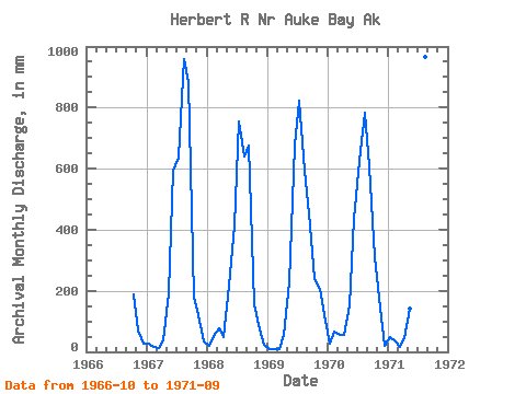
| Year | Jan | Feb | Mar | Apr | May | Jun | Jul | Aug | Sep | Oct | Nov | Dec | Annual | 1966 | 193.62 | 68.48 | 26.30 | 1967 | 26.50 | 14.74 | 12.78 | 37.61 | 198.22 | 594.93 | 657.69 | 990.76 | 884.32 | 182.64 | 119.29 | 35.27 | 3742.17 | 1968 | 19.67 | 50.11 | 77.93 | 48.13 | 224.13 | 415.07 | 781.16 | 660.28 | 677.13 | 159.55 | 73.88 | 23.55 | 3197.40 | 1969 | 9.81 | 8.02 | 9.82 | 56.72 | 235.49 | 676.05 | 851.20 | 612.95 | 451.77 | 247.42 | 205.92 | 124.39 | 3473.08 | 1970 | 27.33 | 63.53 | 58.90 | 56.72 | 158.84 | 435.70 | 645.83 | 810.04 | 606.18 | 320.66 | 145.47 | 19.50 | 3335.30 | 1971 | 51.03 | 35.58 | 16.77 | 45.11 | 146.19 | 400.93 | 784.14 | 998.73 | 577.25 |
|---|
 Return to R-Arctic Net Home Page