|
|
|||||||||||||||||
| Point ID: 9294 | Downloads | Plots | Site Data | Code: 15081610 |
|
|
|||||||||||||||||
| Download | |
|---|---|
| Site Descriptor Information | Site Time Series Data |
| Link to all available data | |

|

|
| View: | Statistics | Time Series |
| Units: | m3/s |
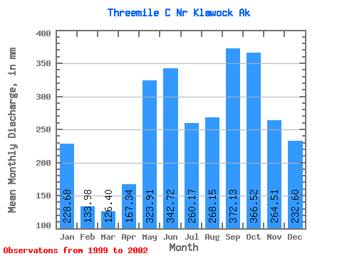
| Statistic | Jan | Feb | Mar | Apr | May | Jun | Jul | Aug | Sep | Oct | Nov | Dec | Annual |
|---|---|---|---|---|---|---|---|---|---|---|---|---|---|
| Mean | 228.60 | 135.08 | 126.42 | 167.39 | 323.87 | 342.66 | 260.05 | 268.04 | 372.10 | 366.50 | 264.50 | 232.56 | 2838.01 |
| Standard Deviation | 75.77 | 24.41 | 50.77 | 45.72 | 59.77 | 88.95 | 37.72 | 97.67 | 108.46 | 120.86 | 24.11 | 20.48 | 340.50 |
| Min | 159.65 | 108.26 | 70.91 | 109.72 | 248.91 | 267.40 | 211.11 | 167.49 | 246.81 | 264.50 | 247.95 | 213.29 | 2597.23 |
| Max | 309.71 | 155.99 | 186.68 | 214.89 | 393.97 | 461.71 | 303.04 | 401.56 | 505.19 | 499.98 | 292.16 | 254.07 | 3078.78 |
| Coefficient of Variation | 0.33 | 0.18 | 0.40 | 0.27 | 0.18 | 0.26 | 0.14 | 0.36 | 0.29 | 0.33 | 0.09 | 0.09 | 0.12 |
| Year | Jan | Feb | Mar | Apr | May | Jun | Jul | Aug | Sep | Oct | Nov | Dec | Annual | 1999 | 101.60 | 214.89 | 393.97 | 461.71 | 303.04 | 243.34 | 398.60 | 499.98 | 292.16 | 254.07 | 2000 | 159.65 | 108.26 | 146.51 | 154.66 | 248.91 | 282.42 | 264.82 | 259.78 | 246.81 | 264.50 | 253.39 | 213.29 | 2597.23 | 2001 | 309.71 | 140.98 | 186.68 | 190.30 | 317.00 | 359.12 | 261.22 | 167.49 | 337.78 | 335.01 | 247.95 | 230.32 | 3078.78 | 2002 | 216.44 | 155.99 | 70.91 | 109.72 | 335.60 | 267.40 | 211.11 | 401.56 | 505.19 |
|---|
 Return to R-Arctic Net Home Page