|
|
|||||||||||||||||
| Point ID: 9281 | Downloads | Plots | Site Data | Code: 15028000 |
|
|
|||||||||||||||||
| Download | |
|---|---|
| Site Descriptor Information | Site Time Series Data |
| Link to all available data | |
|
|
| View: | Statistics | Time Series |
| Units: | m3/s |
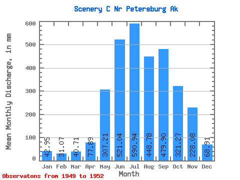
| Statistic | Jan | Feb | Mar | Apr | May | Jun | Jul | Aug | Sep | Oct | Nov | Dec | Annual |
|---|---|---|---|---|---|---|---|---|---|---|---|---|---|
| Mean | 42.93 | 31.34 | 40.70 | 77.90 | 307.14 | 521.02 | 590.86 | 448.72 | 479.90 | 321.23 | 228.06 | 68.88 | 2863.26 |
| Standard Deviation | 9.90 | 10.27 | 13.58 | 32.39 | 37.47 | 77.16 | 79.03 | 79.38 | 108.79 | 129.29 | 190.25 | 9.80 | 43.89 |
| Min | 34.16 | 22.23 | 29.30 | 42.16 | 267.92 | 442.18 | 535.88 | 362.77 | 354.42 | 200.26 | 105.70 | 58.56 | 2832.22 |
| Max | 53.66 | 42.47 | 55.72 | 105.33 | 342.56 | 596.37 | 681.42 | 519.27 | 547.88 | 457.48 | 447.25 | 78.06 | 2894.30 |
| Coefficient of Variation | 0.23 | 0.33 | 0.33 | 0.42 | 0.12 | 0.15 | 0.13 | 0.18 | 0.23 | 0.40 | 0.83 | 0.14 | 0.01 |
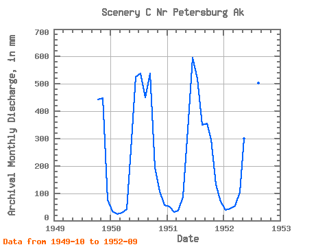
| Year | Jan | Feb | Mar | Apr | May | Jun | Jul | Aug | Sep | Oct | Nov | Dec | Annual | 1949 | 457.48 | 447.25 | 78.06 | 1950 | 34.16 | 22.23 | 29.30 | 42.16 | 267.92 | 524.52 | 555.28 | 464.12 | 537.40 | 200.26 | 105.70 | 58.56 | 2832.22 | 1951 | 53.66 | 29.33 | 37.09 | 86.21 | 342.56 | 596.37 | 535.88 | 362.77 | 354.42 | 305.95 | 131.24 | 70.02 | 2894.30 | 1952 | 40.98 | 42.47 | 55.72 | 105.33 | 310.95 | 442.18 | 681.42 | 519.27 | 547.88 |
|---|
 Return to R-Arctic Net Home Page