|
|
|||||||||||||||||
| Point ID: 9277 | Downloads | Plots | Site Data | Code: 15024000 |
|
|
|||||||||||||||||
| Download | |
|---|---|
| Site Descriptor Information | Site Time Series Data |
| Link to all available data | |
|
|
| View: | Statistics | Time Series |
| Units: | m3/s |
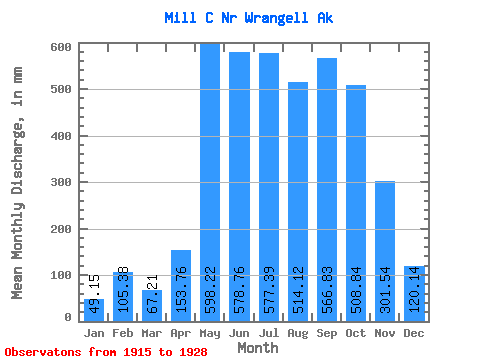
| Statistic | Jan | Feb | Mar | Apr | May | Jun | Jul | Aug | Sep | Oct | Nov | Dec | Annual |
|---|---|---|---|---|---|---|---|---|---|---|---|---|---|
| Mean | 49.15 | 106.29 | 67.20 | 153.75 | 598.13 | 578.76 | 577.31 | 514.06 | 566.82 | 508.75 | 301.53 | 120.12 | 3803.03 |
| Standard Deviation | 20.32 | 55.61 | 38.09 | 43.03 | 222.83 | 107.23 | 108.51 | 102.00 | 76.49 | 27.73 | 163.16 | 36.34 | |
| Min | 30.90 | 57.69 | 40.50 | 105.32 | 318.03 | 365.95 | 349.68 | 347.11 | 489.65 | 480.66 | 158.90 | 78.29 | 3803.03 |
| Max | 71.04 | 166.94 | 110.82 | 187.58 | 844.74 | 681.85 | 673.30 | 623.98 | 647.22 | 533.39 | 514.90 | 143.91 | 3803.03 |
| Coefficient of Variation | 0.41 | 0.52 | 0.57 | 0.28 | 0.37 | 0.18 | 0.19 | 0.20 | 0.14 | 0.06 | 0.54 | 0.30 |
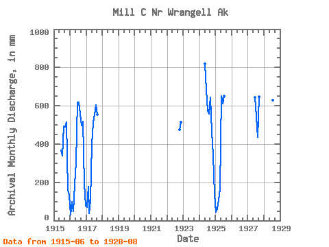
| Year | Jan | Feb | Mar | Apr | May | Jun | Jul | Aug | Sep | Oct | Nov | Dec | Annual | 1915 | 365.95 | 349.68 | 510.28 | 489.65 | 531.76 | 158.90 | 138.17 | 1916 | 30.90 | 94.26 | 50.27 | 187.58 | 318.03 | 617.47 | 639.92 | 575.91 | 497.34 | 533.39 | 190.36 | 78.29 | 3803.03 | 1917 | 71.04 | 166.94 | 40.50 | 105.32 | 414.66 | 511.13 | 572.33 | 623.98 | 555.45 | 1922 | 489.19 | 514.90 | 1924 | 844.74 | 681.85 | 593.69 | 577.67 | 644.44 | 480.66 | 341.96 | 143.91 | 1925 | 45.50 | 57.69 | 110.82 | 168.35 | 673.88 | 610.98 | 673.30 | 1927 | 644.36 | 562.86 | 449.41 | 647.22 | 1928 | 739.33 | 619.59 | 649.37 | 347.11 |
|---|
 Return to R-Arctic Net Home Page