|
|
|||||||||||||||||
| Point ID: 9274 | Downloads | Plots | Site Data | Code: 15020100 |
|
|
|||||||||||||||||
| Download | |
|---|---|
| Site Descriptor Information | Site Time Series Data |
| Link to all available data | |

|

|
| View: | Statistics | Time Series |
| Units: | m3/s |
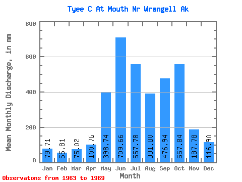
| Statistic | Jan | Feb | Mar | Apr | May | Jun | Jul | Aug | Sep | Oct | Nov | Dec | Annual |
|---|---|---|---|---|---|---|---|---|---|---|---|---|---|
| Mean | 79.71 | 56.30 | 75.00 | 100.78 | 398.68 | 709.64 | 557.68 | 391.75 | 476.95 | 557.78 | 187.79 | 116.87 | 3749.51 |
| Standard Deviation | 52.10 | 27.75 | 57.99 | 37.60 | 104.37 | 113.38 | 35.13 | 128.06 | 217.14 | 151.92 | 66.20 | 50.43 | 271.19 |
| Min | 24.45 | 21.24 | 20.12 | 40.42 | 273.66 | 557.43 | 518.13 | 190.01 | 190.80 | 403.89 | 105.67 | 69.33 | 3390.69 |
| Max | 163.31 | 84.57 | 182.14 | 134.65 | 517.05 | 869.28 | 617.55 | 568.09 | 765.59 | 791.12 | 273.18 | 206.90 | 4107.89 |
| Coefficient of Variation | 0.65 | 0.49 | 0.77 | 0.37 | 0.26 | 0.16 | 0.06 | 0.33 | 0.46 | 0.27 | 0.35 | 0.43 | 0.07 |
| Year | Jan | Feb | Mar | Apr | May | Jun | Jul | Aug | Sep | Oct | Nov | Dec | Annual | 1963 | 190.01 | 501.05 | 604.99 | 114.53 | 206.90 | 1964 | 121.19 | 80.85 | 48.51 | 95.04 | 273.66 | 787.01 | 617.55 | 568.09 | 347.10 | 646.34 | 186.93 | 143.54 | 3899.49 | 1965 | 163.31 | 76.64 | 76.44 | 134.65 | 281.17 | 636.40 | 569.89 | 292.73 | 190.80 | 791.12 | 105.67 | 90.86 | 3390.69 | 1966 | 46.69 | 30.95 | 86.41 | 131.89 | 383.47 | 658.00 | 557.43 | 481.32 | 549.63 | 403.89 | 224.47 | 91.28 | 3634.04 | 1967 | 66.00 | 43.55 | 36.37 | 40.42 | 491.47 | 869.28 | 554.80 | 436.74 | 709.63 | 495.11 | 273.18 | 99.32 | 4107.89 | 1968 | 56.62 | 84.57 | 182.14 | 76.04 | 445.25 | 557.43 | 528.28 | 328.80 | 765.59 | 405.24 | 221.95 | 69.33 | 3715.44 | 1969 | 24.45 | 21.24 | 20.12 | 126.61 | 517.05 | 749.76 | 518.13 | 444.54 | 274.87 |
|---|
 Return to R-Arctic Net Home Page