|
|
|||||||||||||||||
| Point ID: 9270 | Downloads | Plots | Site Data | Code: 15016000 |
|
|
|||||||||||||||||
| Download | |
|---|---|
| Site Descriptor Information | Site Time Series Data |
| Link to all available data | |
|
|
| View: | Statistics | Time Series |
| Units: | m3/s |
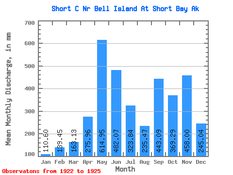
| Statistic | Jan | Feb | Mar | Apr | May | Jun | Jul | Aug | Sep | Oct | Nov | Dec | Annual |
|---|---|---|---|---|---|---|---|---|---|---|---|---|---|
| Mean | 110.57 | 140.67 | 163.12 | 275.95 | 614.85 | 482.09 | 323.76 | 235.45 | 443.10 | 369.26 | 458.03 | 245.02 | 4144.17 |
| Standard Deviation | 108.35 | 129.77 | 36.80 | 79.83 | 70.22 | 34.99 | 84.00 | 66.02 | 159.63 | 110.10 | 101.48 | 97.94 | 215.69 |
| Min | 41.01 | 20.01 | 131.76 | 226.94 | 534.43 | 456.67 | 205.92 | 145.40 | 220.19 | 248.07 | 309.37 | 187.40 | 3991.65 |
| Max | 235.41 | 277.94 | 203.63 | 368.07 | 663.97 | 522.00 | 403.30 | 292.27 | 578.35 | 497.55 | 534.99 | 358.10 | 4296.69 |
| Coefficient of Variation | 0.98 | 0.92 | 0.23 | 0.29 | 0.11 | 0.07 | 0.26 | 0.28 | 0.36 | 0.30 | 0.22 | 0.40 | 0.05 |
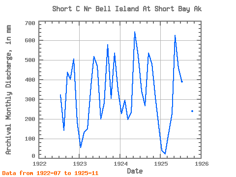
| Year | Jan | Feb | Mar | Apr | May | Jun | Jul | Aug | Sep | Oct | Nov | Dec | Annual | 1922 | 332.48 | 145.40 | 438.82 | 416.66 | 506.23 | 189.57 | 1923 | 55.30 | 124.05 | 153.95 | 368.07 | 534.43 | 467.59 | 205.92 | 292.27 | 578.35 | 314.75 | 534.99 | 358.10 | 3991.65 | 1924 | 235.41 | 277.94 | 203.63 | 232.85 | 663.97 | 522.00 | 353.36 | 276.40 | 535.03 | 497.55 | 309.37 | 187.40 | 4296.69 | 1925 | 41.01 | 20.01 | 131.76 | 226.94 | 646.16 | 456.67 | 403.30 | 227.72 | 220.19 | 248.07 | 481.52 |
|---|
 Return to R-Arctic Net Home Page